IMAGES TAKEN NEAR TO
Ravenshoe Road, BARRY, CF63 2AU
Introduction
This page details the photographs taken nearby to Ravenshoe Road, CF63 2AU by members of the Geograph project.
The Geograph project started in 2005 with the aim of publishing, organising and preserving representative images for every square kilometre of Great Britain, Ireland and the Isle of Man.

There are currently over 7.5m images from over14,400 individuals and you can help contribute to the project by visiting https://www.geograph.org.uk
Image Map
Images are licensed for reuse under creativecommons.org/licenses/by-sa/2.0
Notes
- Clicking on the map will re-center to the selected point.
- The higher the marker number, the further away the image location is from the centre of the postcode.
Image Listing (67 Images Found)
Images are licensed for reuse under creativecommons.org/licenses/by-sa/2.0
Image
Details
Distance
1
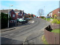
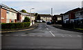
Ravenshoe Road, Barry
Ravenshoe Road is a long cul-de-sac on the north side of Langlands Road.
I wondered whether the name is pronounced Raven's Hoe or Raven Shoe - both of which seemed rather silly! I haven't discovered which is correct but I did find out that the road is named after S.S. Ravenshoe, a steam-propelled cargo ship of the last quarter of the 19th century, the first ever ship to load coal in Barry Docks.
Image: © Jaggery
Taken: 2 Dec 2012
0.02 miles
2
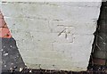
Ordnance Survey Cut Mark
This OS cut mark can be found on the wall of No11 Dobbins Road. It marks a point 25.762m above mean sea level.
Image: © Adrian Dust
Taken: 3 Feb 2018
0.03 miles
3
Runcorn Close, Barry
Cul-de-sac on the east side of Langlands Road.
Image: © Jaggery
Taken: 4 Nov 2016
0.05 miles
4
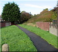
Path on the north side of Langlands Road, Barry
Opposite Falcon Road.
Image: © Jaggery
Taken: 4 Nov 2016
0.06 miles
5

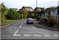
East along Langlands Road, Barry
Towards Dobbins Road past the right turn into Falcon Road.
Image: © Jaggery
Taken: 4 Nov 2016
0.06 miles
6

Junction of Langlands Road and Dobbins Road, Barry
From Langlands Road towards an allotments perimeter fence on the east side of Dobbins Road.
Image: © Jaggery
Taken: 4 Nov 2016
0.06 miles
7

Vandalised BT phonebox on a Barry corner
In early November 2016, the box on the corner of Dobbins Road and Langlands Road is a BT box, but no longer a BT phonebox. The box contains telephone equipment but not a handset, no doubt the result of vandalism.
Image: © Jaggery
Taken: 4 Nov 2016
0.06 miles
8
Phildelphia Close, Barry
Cul-de-sac on the east side of Langlands Road.
Image: © Jaggery
Taken: 4 Nov 2016
0.07 miles
9

Southern end of Phildelphia Close, Barry
Looking north from the edge of Langlands Road.
Image: © Jaggery
Taken: 4 Nov 2016
0.07 miles
10

West along Langlands Road, Barry
From the corner of Dobbins Road.
Image: © Jaggery
Taken: 4 Nov 2016
0.07 miles