IMAGES TAKEN NEAR TO
Arno Road, BARRY, CF63 2AS
Introduction
This page details the photographs taken nearby to Arno Road, CF63 2AS by members of the Geograph project.
The Geograph project started in 2005 with the aim of publishing, organising and preserving representative images for every square kilometre of Great Britain, Ireland and the Isle of Man.

There are currently over 7.5m images from over14,400 individuals and you can help contribute to the project by visiting https://www.geograph.org.uk
Image Map
Images are licensed for reuse under creativecommons.org/licenses/by-sa/2.0
Notes
- Clicking on the map will re-center to the selected point.
- The higher the marker number, the further away the image location is from the centre of the postcode.
Image Listing (196 Images Found)
Images are licensed for reuse under creativecommons.org/licenses/by-sa/2.0
Image
Details
Distance
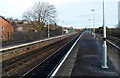
1
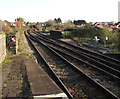
Railway northeast of Cadoxton station
Next station ahead on the route to Cardiff Central is Dinas Powys.
Red and white notices on the left and right show WARNING - LIMITED CLEARANCE.
Image: © Jaggery
Taken: 11 Nov 2019
0.06 miles
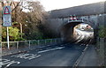
2
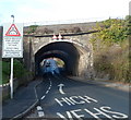
East side of Little Moors Hill railway bridges, Cadoxton
The sign showing ARCH BRIDGE is slightly inaccurate in that there are two arch bridges here, 6 metres apart. The nearer one carries a probably little used single track. The other one carries the two tracks
of the Vale of Glamorgan line immediately NE of Cadoxton station. http://www.geograph.org.uk/photo/3246730
An arrow directs drivers of high vehicles to a middle course under the arch bridges.
Image: © Jaggery
Taken: 2 Dec 2012
0.06 miles
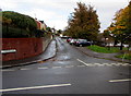
3
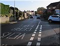
Little Moors Hill, Barry
From the corner of Churchill Terrace, Little Moors Hill ascends towards two railway bridges. http://www.geograph.org.uk/photo/3246836
Image: © Jaggery
Taken: 4 Nov 2016
0.06 miles
4
Old Mill Road, Cadoxton, Barry
Dead-end road on the NE side of Little Moors Hill.
Image: © Jaggery
Taken: 4 Nov 2016
0.06 miles
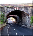
5
West side of Little Moors Hill railway bridges, Cadoxton
There are two parallel railway bridges http://www.geograph.org.uk/photo/3246836 over Little Moors Hill here. The nearer one carries the two tracks of the Vale of Glamorgan line immediately NE of Cadoxton station. http://www.geograph.org.uk/photo/3246730
The other one carries a single track.
The highest overhead clearance under the arch bridges is 12' 9" (3.9m).
The signs tells drivers of high vehicles to use the middle of the road.
Image: © Jaggery
Taken: 2 Dec 2012
0.06 miles
6
Two arched railway bridges over Little Moors Hill, Barry
The Network Rail nameplates on the bridges show that the Relief Lines Span is nearer the camera.
The Main Lines Span is in the background. Headroom shown is 12' 9"/3.9m.
High vehicles need to use the middle of the roadway.
Image: © Jaggery
Taken: 4 Nov 2016
0.06 miles
7
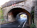
West side of Little Moors Hill arched railway bridges, Barry
The Network Rail nameplates on the bridges show that the Main Lines Span is nearer the camera. The Relief Lines Span is in the background. Headroom shown is 12' 9"/3.9m. High vehicles need to use the middle of the roadway.
Image: © Jaggery
Taken: 4 Nov 2016
0.06 miles
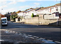
8
Junction of Little Moors Hill and Gradon Close, Cadoxton
From the right, Gradon Close joins Little Moors Hill.
Image: © Jaggery
Taken: 11 Nov 2019
0.06 miles
9
Cadoxton railway station
A view from the SW corner of the station which is on the Vale of Glamorgan
line between Dinas Powys station (ahead) and Barry Docks station.
Image: © Jaggery
Taken: 2 Dec 2012
0.06 miles
10
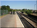
The view NE from Cadoxton Railway Station
The lines head in the direction of Cardiff. Next stop is Dinas Powys.
The brickwork on the right, beyond the platform and adjacent to the track connecting the two lines, is part of the railway bridge across Little Moors Hill. http://www.geograph.org.uk/photo/1917903
Image: © Jaggery
Taken: 16 Jun 2010
0.07 miles