IMAGES TAKEN NEAR TO
Treharne Road, BARRY, CF63 1QY
Introduction
This page details the photographs taken nearby to Treharne Road, CF63 1QY by members of the Geograph project.
The Geograph project started in 2005 with the aim of publishing, organising and preserving representative images for every square kilometre of Great Britain, Ireland and the Isle of Man.

There are currently over 7.5m images from over14,400 individuals and you can help contribute to the project by visiting https://www.geograph.org.uk
Image Map
Images are licensed for reuse under creativecommons.org/licenses/by-sa/2.0
Notes
- Clicking on the map will re-center to the selected point.
- The higher the marker number, the further away the image location is from the centre of the postcode.
Image Listing (56 Images Found)
Images are licensed for reuse under creativecommons.org/licenses/by-sa/2.0
Image
Details
Distance
1
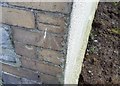
Ordnance Survey Cut Mark
This OS cut mark can be found on No33 Treharne Road. It marks a point 36.580m above mean sea level.
Image: © Adrian Dust
Taken: 3 Feb 2018
0.02 miles
2
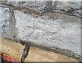
Ordnance Survey Cut Mark
This OS cut mark can be found on No16 Bridge Street. It marks a point 29.163m above mean sea level.
Image: © Adrian Dust
Taken: 3 Feb 2018
0.08 miles
4
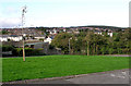
Cadoxton, Barry
A north Barry suburb. The white building showing the pine end is the locally famous "King Billy" public house
Image: © Tony Hodge
Taken: 31 Oct 2006
0.11 miles
5
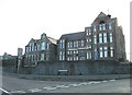
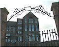
Cadoxton Schools, Victoria Park Road, Barry
These magnificent late Victorian schools are a dominant feature on Cadoxton Hill and can be seen from miles around.
Image: © Tony Hodge
Taken: 31 Oct 2006
0.11 miles
6
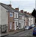
Beverley Street, Cadoxton, Barry
Beverley Street is an 80 metre long cul-de-sac. Viewed from the Main Street end.
Image: © Jaggery
Taken: 28 Feb 2013
0.14 miles
7
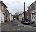
Abingdon Street, Cadoxton, Barry
Abingdon Street is a 60 metre long cul-de-sac.
Viewed across Main Street past a Spar http://www.geograph.org.uk/photo/3351673 on the corner.
Image: © Jaggery
Taken: 28 Feb 2013
0.16 miles
8

Children's Playground
Children's playground in Cadoxton.
Image: © Alan Hughes
Taken: 6 Jun 2017
0.17 miles
9
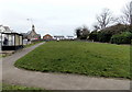
Victoria Gardens, Cadoxton, Barry
Victoria Gardens is an open space, about 60 metres by 20 metres, on the east side of Church Road. Cadoxton Methodist Church http://www.geograph.org.uk/photo/3351276 is in the background.
Image: © Jaggery
Taken: 28 Feb 2013
0.17 miles
10
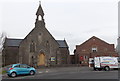
Cadoxton Methodist church and hall, Barry
Located on the north side of Church Road, Cadoxton, Barry.
The church was built in 1862, when Cadoxton was a small village, separate from Barry, which was also a small village at that time, with a population of less than 100. The date stone on the hall on the right shows 1931.
Image: © Jaggery
Taken: 28 Feb 2013
0.18 miles