IMAGES TAKEN NEAR TO
Gladstone Road, BARRY, CF63 1QG
Introduction
This page details the photographs taken nearby to Gladstone Road, CF63 1QG by members of the Geograph project.
The Geograph project started in 2005 with the aim of publishing, organising and preserving representative images for every square kilometre of Great Britain, Ireland and the Isle of Man.

There are currently over 7.5m images from over14,400 individuals and you can help contribute to the project by visiting https://www.geograph.org.uk
Image Map
Images are licensed for reuse under creativecommons.org/licenses/by-sa/2.0
Notes
- Clicking on the map will re-center to the selected point.
- The higher the marker number, the further away the image location is from the centre of the postcode.
Image Listing (114 Images Found)
Images are licensed for reuse under creativecommons.org/licenses/by-sa/2.0
Image
Details
Distance
1
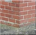
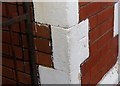
Ordnance Survey Cut Mark
This OS cut mark can be found on No448 Gladstone Road. It marks a point 32.720m above mean sea level.
Image: © Adrian Dust
Taken: 3 Feb 2018
0.04 miles
2
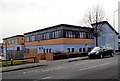
Court Road side of The HUB, Barry
Barry YMCA was established in the town in 1890. By 1997, Barry YMCA was near closure, with no money, the old building in disrepair and only four staff remaining. Gymnastics was the only activity keeping the centre open. Then a new management team was formed and a development plan put in place. The result was the HUB seen here, a £2¾ million building, entrance on the Gladstone Road side, which was constructed in 2005. It opened on January 12th 2006. Some details and figures from 2009 show the success of the new building:
Income is generated from the sale of membership services, room hire and continuous fundraising.
46 people are employed, supported by 38 dedicated volunteers.
The HUB is home to 5 other charities, a small business and a dedicated day unit for adults with multiple disabilities.
In an average week, more than 1,000 children and young people attend activities here.
Another 3000 people (parents, general public and hirers) also use the HUB each week.
Image: © Jaggery
Taken: 28 Feb 2013
0.05 miles
3
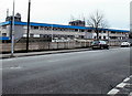
Court Road side of Barry Police Station
Looking at first glance like a telephone exchange, this 90 metre long building is Barry Police Station, part of the South Wales Police force. The station entrance is in Gladstone Street.
Image: © Jaggery
Taken: 28 Feb 2013
0.07 miles
4
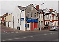
Best-one corner shop, Barry
The shop is on the corner of Court Road and Hannah Street.
Image: © Jaggery
Taken: 28 Feb 2013
0.08 miles
5
Ordnance Survey Cut Mark
This OS cut mark can be found on No77 Court Road. It marks a point 40.685m above mean sea level.
Image: © Adrian Dust
Taken: 3 Feb 2018
0.09 miles
6
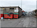
Not an entrance to Court Road Depot, Barry
The location is near the corner of Gladstone Road and Court Road. A notice on the wall and another one on the gate state that the depot entrance is from the traffic lights at the Barry Road - Dyfan Road junction.
Image: © Jaggery
Taken: 28 Feb 2013
0.10 miles
7
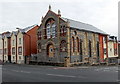
Corner view of the former Bethel chapel, Barry
Now converted to flats, the building opened in 1891 as the Bethel Presbyterian Chapel.
The location is the corner of Court Road and Newton Street.
http://www.geograph.org.uk/photo/3353164 to a front view.
Image: © Jaggery
Taken: 28 Feb 2013
0.10 miles
8
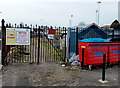
Entrance gate to Slaughterhouse Allotments, Barry
The entrance to the allotments http://www.geograph.org.uk/photo/3353740 is from Gladstone Road.
On the right is the edge of a long L-shaped area http://www.geograph.org.uk/photo/3353707 of recycling bins.
The floodlights in the background are in Jenner Park Stadium, the home ground of Barry Town F.C. (football club).
Image: © Jaggery
Taken: 28 Feb 2013
0.10 miles
9
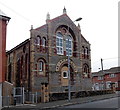
Former Bethel chapel, Barry
Now converted into flats, the building opened in 1891 as the Bethel Presbyterian Chapel.
The location is the corner of Court Road and Newton Street.
Image: © Jaggery
Taken: 28 Feb 2013
0.11 miles
10
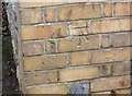
Ordnance Survey Cut Mark
This OS cut mark can be found on the Bethel Chapel, Court Road. It marks a point 37.743m above mean sea level.
Image: © Adrian Dust
Taken: 3 Feb 2018
0.11 miles