1
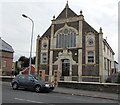
Flats in former Capel Calfaria, Barry
The former Capel Calfaria (Calvary Chapel) on the corner of Court Road and Dovedale Street
has been converted to flats. The chapel was built in 1897.
Image: © Jaggery
Taken: 28 Feb 2013
0.01 miles
2
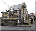
Side view of the former Capel Calfaria, Barry
This is the Dovedale Street side of flats in the former Capel Calfaria
(Calvary Chapel) on the corner of Court Road. The chapel was built in 1897.
Image: © Jaggery
Taken: 28 Feb 2013
0.02 miles
3
Sold vacant premises on the corner of Court Road and Ilminster Road, Barry
Viewed across Court Road. The estate agents' board on the empty property shows SOLD.
Image: © Jaggery
Taken: 28 Feb 2013
0.02 miles
4
Court Mews, Barry
Located on the corner of Court Road and Chilcote Street, Court Mews contains 13 flats.
Tom Clemett's History of Barry records that this was formerly The Court Hotel. In the early 1900s it opened as the Court Laundry. The now demolished stabling quarters of the hotel were used by Lever Bros Corn Merchants for many years, and then by Cliff Morgan for the same business. It later became a joinery works for Messrs Woodroffe, an office and depot for D. Hopkins painting contractors, and finally joinery works for R. James.
Image: © Jaggery
Taken: 28 Feb 2013
0.02 miles
5
Ordnance Survey Cut Mark
This OS cut mark can be found on No17 Chilcote Street. It marks a point 29.081m above mean sea level.
Image: © Adrian Dust
Taken: 3 Feb 2018
0.05 miles
6
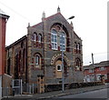
Former Bethel chapel, Barry
Now converted into flats, the building opened in 1891 as the Bethel Presbyterian Chapel.
The location is the corner of Court Road and Newton Street.
Image: © Jaggery
Taken: 28 Feb 2013
0.05 miles
7
Llanover Street, Cadoxton, Barry
Viewed across Kenilworth Road looking along Llanover Street towards Court Road.
Image: © Jaggery
Taken: 28 Feb 2013
0.05 miles
8
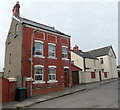
Detached house, Mount Pleasant, Cadoxton, Barry
Below the roofline of the house on the left, there are what look like three bricked-up windows.
The bricks inside the three white frames are orientated diagonally
in contrast with the horizontality of the other bricks in the wall.
Image: © Jaggery
Taken: 28 Feb 2013
0.05 miles
9
Corner view of the former Bethel chapel, Barry
Now converted to flats, the building opened in 1891 as the Bethel Presbyterian Chapel.
The location is the corner of Court Road and Newton Street.
http://www.geograph.org.uk/photo/3353164 to a front view.
Image: © Jaggery
Taken: 28 Feb 2013
0.05 miles
10
Ordnance Survey Cut Mark
This OS cut mark can be found on the Bethel Chapel, Court Road. It marks a point 37.743m above mean sea level.
Image: © Adrian Dust
Taken: 3 Feb 2018
0.06 miles


