IMAGES TAKEN NEAR TO
Gilbert Street, BARRY, CF63 1EE
Introduction
This page details the photographs taken nearby to Gilbert Street, CF63 1EE by members of the Geograph project.
The Geograph project started in 2005 with the aim of publishing, organising and preserving representative images for every square kilometre of Great Britain, Ireland and the Isle of Man.

There are currently over 7.5m images from over14,400 individuals and you can help contribute to the project by visiting https://www.geograph.org.uk
Image Map
Images are licensed for reuse under creativecommons.org/licenses/by-sa/2.0
Notes
- Clicking on the map will re-center to the selected point.
- The higher the marker number, the further away the image location is from the centre of the postcode.
Image Listing (56 Images Found)
Images are licensed for reuse under creativecommons.org/licenses/by-sa/2.0
Image
Details
Distance
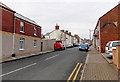
1
Llewellyn Street, Barry
Viewed from the Court Road end looking towards Barry Road.
Image: © Jaggery
Taken: 28 Feb 2013
0.06 miles
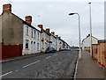
2
Davies Street, Barry
Viewed from the Court Road end looking towards Barry Road.
Image: © Jaggery
Taken: 28 Feb 2013
0.07 miles
3
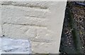
Ordnance Survey Cut Mark
This OS cut mark can be found on No2 Commercial Road. It marks a point 45.233m above mean sea level.
Image: © Adrian Dust
Taken: 3 Feb 2018
0.10 miles
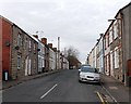
4
Commercial Road, Barry
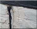
Viewed from the Court Road end looking towards Barry Road. No doubt named at a time where there were shops and other businesses in this street, Commercial Road in 2013 is a residential street, with only one shop, on the corner of Court Road. One possible remnant of a former commercial use is the fragment of an archway remaining in the wall on the right.
Image: © Jaggery
Taken: 28 Feb 2013
0.10 miles
5
Ordnance Survey Cut Mark
This OS cut mark can be found on No144 Barry Road. It marks a point 46.702m above mean sea level.
Image: © Adrian Dust
Taken: 3 Feb 2018
0.13 miles
6
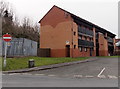
Ty Cerrig, Cadoxton , Barry,
Built in 1990, Ty Cerrig is located at the southern end of Robins Lane, near the junctions with Court Road, Beverley Street and Main Street. Managed by the Cadarn Housing Group, Ty Cerrig contains
12 1-bedroom rented flats with a community alarm service. New residents must be at least 55 years old.
Image: © Jaggery
Taken: 28 Feb 2013
0.14 miles
7
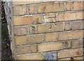
Ordnance Survey Cut Mark
This OS cut mark can be found on the Bethel Chapel, Court Road. It marks a point 37.743m above mean sea level.
Image: © Adrian Dust
Taken: 3 Feb 2018
0.14 miles
8
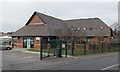
The Practice of Health Surgery, Barry
This is the Court Road side of The Practice of Health Surgery, address 31 Barry Road.
Image: © Jaggery
Taken: 28 Feb 2013
0.15 miles
9
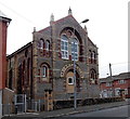
Former Bethel chapel, Barry
Now converted into flats, the building opened in 1891 as the Bethel Presbyterian Chapel.
The location is the corner of Court Road and Newton Street.
Image: © Jaggery
Taken: 28 Feb 2013
0.15 miles
10
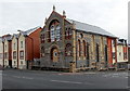
Corner view of the former Bethel chapel, Barry
Now converted to flats, the building opened in 1891 as the Bethel Presbyterian Chapel.
The location is the corner of Court Road and Newton Street.
http://www.geograph.org.uk/photo/3353164 to a front view.
Image: © Jaggery
Taken: 28 Feb 2013
0.16 miles