IMAGES TAKEN NEAR TO
Hywel Crescent, BARRY, CF63 1DL
Introduction
This page details the photographs taken nearby to Hywel Crescent, CF63 1DL by members of the Geograph project.
The Geograph project started in 2005 with the aim of publishing, organising and preserving representative images for every square kilometre of Great Britain, Ireland and the Isle of Man.

There are currently over 7.5m images from over14,400 individuals and you can help contribute to the project by visiting https://www.geograph.org.uk
Image Map
Images are licensed for reuse under creativecommons.org/licenses/by-sa/2.0
Notes
- Clicking on the map will re-center to the selected point.
- The higher the marker number, the further away the image location is from the centre of the postcode.
Image Listing (28 Images Found)
Images are licensed for reuse under creativecommons.org/licenses/by-sa/2.0
Image
Details
Distance
1
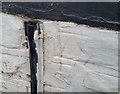
Ordnance Survey Cut Mark
This OS cut mark can be found on No144 Barry Road. It marks a point 46.702m above mean sea level.
Image: © Adrian Dust
Taken: 3 Feb 2018
0.03 miles
2
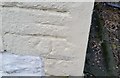
Ordnance Survey Cut Mark
This OS cut mark can be found on No2 Commercial Road. It marks a point 45.233m above mean sea level.
Image: © Adrian Dust
Taken: 3 Feb 2018
0.07 miles
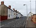
3
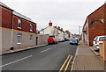
Commercial Road, Barry
Viewed from the Court Road end looking towards Barry Road. No doubt named at a time where there were shops and other businesses in this street, Commercial Road in 2013 is a residential street, with only one shop, on the corner of Court Road. One possible remnant of a former commercial use is the fragment of an archway remaining in the wall on the right.
Image: © Jaggery
Taken: 28 Feb 2013
0.07 miles
4
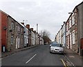
Davies Street, Barry
Viewed from the Court Road end looking towards Barry Road.
Image: © Jaggery
Taken: 28 Feb 2013
0.08 miles
5
Llewellyn Street, Barry
Viewed from the Court Road end looking towards Barry Road.
Image: © Jaggery
Taken: 28 Feb 2013
0.11 miles
6
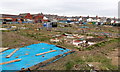
Slaughterhouse Allotments, Barry
Viewed from Gladstone Road. Judging by the name of the allotments, one method of producing food on this site has been replaced by another. The allotment is owned by the Vale of Glamorgan Council. Anyone who lives in the Vale of Glamorgan can apply for one or two plots on any of the council-run allotment sites. Waiting times depend on the site, but it could be months or sometimes years.
Allotment users can grow vegetables or flowers, and keep hens (but not cockerels). Some other types of livestock may be kept, subject to prior permission to do so from the council.
Image: © Jaggery
Taken: 28 Feb 2013
0.12 miles
7
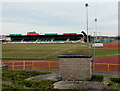
Jenner Park Stadium, Barry
Viewed from near the corner of Gladstone Road and Devon Avenue. Jenner Park has been the home ground of Barry Town football club since 1913. In the 1980s the local council financed the installation of a synthetic running track, floodlights and a new grandstand. In 1996, to bring Jenner Park up to UEFA standards, a second stand was built, as well as a new hospitality complex, dressing rooms, floodlights and clubhouse.
Image: © Jaggery
Taken: 28 Feb 2013
0.14 miles
8
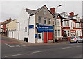
Best-one corner shop, Barry
The shop is on the corner of Court Road and Hannah Street.
Image: © Jaggery
Taken: 28 Feb 2013
0.14 miles
9
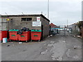
Not an entrance to Court Road Depot, Barry
The location is near the corner of Gladstone Road and Court Road. A notice on the wall and another one on the gate state that the depot entrance is from the traffic lights at the Barry Road - Dyfan Road junction.
Image: © Jaggery
Taken: 28 Feb 2013
0.15 miles
10
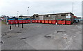
L-shaped arrangement of recycling bins, Barry
The large red Biffa bins have different coloured lettering for different types of items to be recycled.
They are located alongside Gladstone Road near this gate http://www.geograph.org.uk/photo/3353696 which is not an entrance to Court Road depot.
Image: © Jaggery
Taken: 28 Feb 2013
0.15 miles