IMAGES TAKEN NEAR TO
Woodham Park, BARRY, CF62 8FJ
Introduction
This page details the photographs taken nearby to Woodham Park, CF62 8FJ by members of the Geograph project.
The Geograph project started in 2005 with the aim of publishing, organising and preserving representative images for every square kilometre of Great Britain, Ireland and the Isle of Man.

There are currently over 7.5m images from over14,400 individuals and you can help contribute to the project by visiting https://www.geograph.org.uk
Image Map
Images are licensed for reuse under creativecommons.org/licenses/by-sa/2.0
Notes
- Clicking on the map will re-center to the selected point.
- The higher the marker number, the further away the image location is from the centre of the postcode.
Image Listing (13 Images Found)
Images are licensed for reuse under creativecommons.org/licenses/by-sa/2.0
Image
Details
Distance
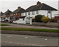
1
Florist shop, Colcot Road, Barry
There is no name on the sign on the left, which shows FLOWERS. The single-storey florists' premises on the left is alongside a house built in 1927.
Image: © Jaggery
Taken: 6 Jan 2013
0.06 miles
2
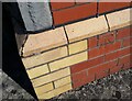
Ordnance Survey Cut Mark
This OS rivet can be found on No54 Colcot Road. It marks a point 86.679m above mean sea level.
Image: © Adrian Dust
Taken: 20 Sep 2021
0.11 miles
3
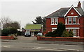
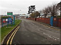
Corner of Colcot Road and Woodham Close, Barry
Viewed across Colcot Road. The street name sign shows Woodham Close leading to Woodham Park.
Image: © Jaggery
Taken: 6 Jan 2013
0.14 miles
4
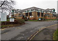
Entrance to Barry Hospital
This entrance from Colcot Road is into the SE corner of the hospital. The smaller of the two signs shows that there is a minor injuries unit here.
Image: © Jaggery
Taken: 6 Jan 2013
0.15 miles
5
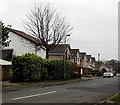
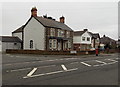
Greenbanks Drive, Barry
These houses on the south side of the street, viewed from
the Colcot Road end looking towards the Glen Mavis Way junction.
Image: © Jaggery
Taken: 6 Jan 2013
0.16 miles
6
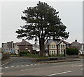
Towering tree at the western end of North Walk, Barry
Viewed across Colcot Road.
Image: © Jaggery
Taken: 6 Jan 2013
0.17 miles
7
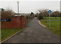
Path along the eastern edge of Barry Hospital
The sign shows that this is a combined footpath and cycleway alongside a perimeter wall of the hospital. http://www.geograph.org.uk/photo/3288317
Image: © Jaggery
Taken: 6 Jan 2013
0.18 miles
8
Dyffryn Place, Barry
Houses at the NE end of Dyffryn Place viewed across Colcot Road.
Dyffryn Place is a cul-de-sac. Houses at SW end are adjacent to the grounds of Barry Hospital.
Image: © Jaggery
Taken: 6 Jan 2013
0.19 miles
9
Entrance to Ysgol Nant Talwg, Barry
This is a Welsh-medium primary school, where all lessons are conducted using the medium of the Welsh language. The school, which opened in September 2011, is adjacent to Barry Hospital. http://www.geograph.org.uk/photo/3288317
Image: © Jaggery
Taken: 6 Jan 2013
0.20 miles
10
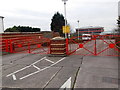
Red entrance gates to Cardiff and Vale College, Barry
This is the Colcot Road entrance to the college. The Vale in its title is Vale of Glamorgan. The gates are closed because today is Sunday.
Image: © Jaggery
Taken: 6 Jan 2013
0.21 miles