IMAGES TAKEN NEAR TO
Tynewydd Road, BARRY, CF62 8BB
Introduction
This page details the photographs taken nearby to Tynewydd Road, CF62 8BB by members of the Geograph project.
The Geograph project started in 2005 with the aim of publishing, organising and preserving representative images for every square kilometre of Great Britain, Ireland and the Isle of Man.

There are currently over 7.5m images from over14,400 individuals and you can help contribute to the project by visiting https://www.geograph.org.uk
Image Map
Images are licensed for reuse under creativecommons.org/licenses/by-sa/2.0
Notes
- Clicking on the map will re-center to the selected point.
- The higher the marker number, the further away the image location is from the centre of the postcode.
Image Listing (36 Images Found)
Images are licensed for reuse under creativecommons.org/licenses/by-sa/2.0
Image
Details
Distance
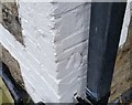
2
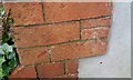
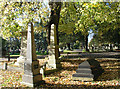
Ordnance Survey Cut Mark
This OS cut mark can be found on No111 Ty Newydd Road. It marks a point 81.259m above mean sea level.
Image: © Adrian Dust
Taken: 3 Feb 2018
0.05 miles
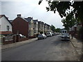
4
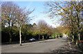
Ty-newydd Road, Barry
Ty-newydd Road climbs northwestwards away from Gladstone Road.
Image: © Jaggery
Taken: 28 Feb 2013
0.09 miles
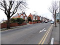
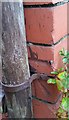
6
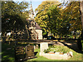
Ordnance Survey Cut Mark
This OS cut mark can be found on No215 Barry Road. It marks a point 72.942m above mean sea level.
Image: © Adrian Dust
Taken: 3 Feb 2018
0.12 miles
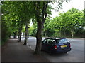
7
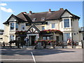
Ordnance Survey Cut Mark
This OS cut mark can be found on No247 Gladstone Road. It marks a point 54.631m above mean sea level.
Image: © Adrian Dust
Taken: 3 Feb 2018
0.13 miles