IMAGES TAKEN NEAR TO
Broad Street, BARRY, CF62 7AD
Introduction
This page details the photographs taken nearby to Broad Street, CF62 7AD by members of the Geograph project.
The Geograph project started in 2005 with the aim of publishing, organising and preserving representative images for every square kilometre of Great Britain, Ireland and the Isle of Man.

There are currently over 7.5m images from over14,400 individuals and you can help contribute to the project by visiting https://www.geograph.org.uk
Image Map (Loading...)


Getting Data...Please wait
Leaflet Map data © OpenStreetMap
Images are licensed for reuse under creativecommons.org/licenses/by-sa/2.0
Notes
- Clicking on the map will re-center to the selected point.
- The higher the marker number, the further away the image location is from the centre of the postcode.
Image Listing (218 Images Found)
Images are licensed for reuse under creativecommons.org/licenses/by-sa/2.0
Image
Details
Distance
1
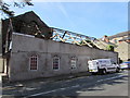
Exposed rafters, East Street, Barry
Viewed in September 2019. The roof seen here https://www.geograph.org.uk/photo/5079955 in August 2016 has gone.
Image: © Jaggery
Taken: 8 Sep 2019
0.00 miles
2
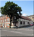
Vacant commercial premises on a Barry corner
In August 2016, estate agents' boards showing A3 Lease Available are on the vacant building on the corner of Broad Street and East Street. A3 indicates that the premises can be used for the sale of food or drink for consumption on the premises, or hot food for consumption off the premises.
Originally a church erected in the 1890s, the building's later uses include the Four Lanterns restaurant and a billiard hall.
Image: © Jaggery
Taken: 18 Aug 2016
0.00 miles
3
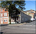
Sold with planning permission on a Barry corner
Roofless https://www.geograph.org.uk/photo/6272368 on September 8th 2019, the derelict building is on the corner of the A4055 Broad Street and East Street. A Brinsons & Birt board on the Broad Street wall shows SOLD WITH PLANNING PERMISSION.
Image: © Jaggery
Taken: 8 Sep 2019
0.01 miles
4
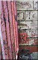
Ordnance Survey Cut Mark
This almost hidden OS cut mark can be found on the NE angle of The Four Lanterns. It marks a point 22.116m above mean sea level.
Image: © Adrian Dust
Taken: 28 Feb 2018
0.01 miles
5
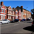
Change of house type, Broad Street, Barry
On the approach to the East Street junction.
Image: © Jaggery
Taken: 8 Sep 2019
0.01 miles
6
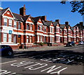
Row of brick houses, Broad Street, Barry
Petherton Veterinary Clinic is on the left.
Image: © Jaggery
Taken: 8 Sep 2019
0.02 miles
7
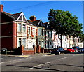
Broad Street houses and trees, Barry
Northeast of East Street on the left.
Image: © Jaggery
Taken: 8 Sep 2019
0.02 miles
8
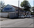
The Furniture Warehouse, Broad Street, Barry
Viewed from the corner of East Street.
Image: © Jaggery
Taken: 8 Sep 2019
0.02 miles
9
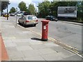
King Edward VII pillarbox, Broad Street, Barry
Broad Street pillarbox viewed from the corner of Trinity Street.
Image: © Jaggery
Taken: 9 Jul 2011
0.03 miles
10
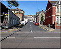
East Street, Barry
From the A4055 Broad Street along East Street towards High Street, Queen Street and Princes Street.
Image: © Jaggery
Taken: 8 Sep 2019
0.03 miles