IMAGES TAKEN NEAR TO
Sea Point, BARRY, CF62 6TB
Introduction
This page details the photographs taken nearby to Sea Point, CF62 6TB by members of the Geograph project.
The Geograph project started in 2005 with the aim of publishing, organising and preserving representative images for every square kilometre of Great Britain, Ireland and the Isle of Man.

There are currently over 7.5m images from over14,400 individuals and you can help contribute to the project by visiting https://www.geograph.org.uk
Image Map
Images are licensed for reuse under creativecommons.org/licenses/by-sa/2.0
Notes
- Clicking on the map will re-center to the selected point.
- The higher the marker number, the further away the image location is from the centre of the postcode.
Image Listing (106 Images Found)
Images are licensed for reuse under creativecommons.org/licenses/by-sa/2.0
Image
Details
Distance
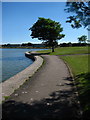
1
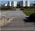
Lakeside flats in Barry
Viewed from steps at the edge of Cold Knap Promenade.
Image: © Jaggery
Taken: 5 Mar 2013
0.01 miles
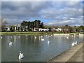
2
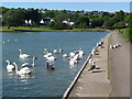
Boating Lake's Eastern Shore
A flock of swans, and a couple of seagulls, by the eastern shore of the boating lake in the park at Cold Knap. Some of the trees here seem to have been shaped by the wind.
Image: © David Roberts
Taken: 24 May 2010
0.04 miles
3

Llyn y Knap Lake
Cerddwyr yn cael seibiant ar lan llyn yn y Bari.
Walkers having a rest at the lake in Barry
Image: © Alan Richards
Taken: 3 Jun 2007
0.04 miles
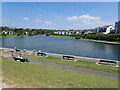
4
Barry: boating lake at The Knapp
A boating lake in the centre of a pleasant park.
Image: © Chris Downer
Taken: 21 Feb 2009
0.05 miles
5

Barry: boating lake and skatepark
The centrepiece of this pleasant park is this lake, while behind it to the left is a skatepark which seemed to be the busiest area just now.
Image: © Chris Downer
Taken: 21 Feb 2009
0.05 miles
6

Site of former Knap Lido
The Lido opened in 1926 and closed in 1997. The site has been landscaped and there are footpaths which follow the outline of the infilled pool
Image: © Eirian Evans
Taken: 23 Jun 2021
0.05 miles
7
Houses at the eastern end of Lakeside, Barry
Viewed from the edge of Watch House Bay. http://www.geograph.org.uk/photo/3957502
Image: © Jaggery
Taken: 5 Mar 2013
0.05 miles
8
Boating Lake's Western Shore
The western shore of the boating lake at Cold Knap, with the water looking very blue on a Spring afternoon. A beach shelter similar to those at Whitmore Bay can be seen ahead.
Image: © David Roberts
Taken: 24 May 2010
0.06 miles
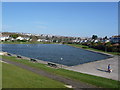
10
The Marine Lake
During the Roman period, this lake area was tidal with a sheltered estuary fed by fresh water from springs above Romilly Park. In the 1920's the Council developed a boating lake in the shape of a Welsh harp.
Image: © Eirian Evans
Taken: 23 Jun 2021
0.07 miles