IMAGES TAKEN NEAR TO
Bron Awelon, BARRY, CF62 6PT
Introduction
This page details the photographs taken nearby to Bron Awelon, CF62 6PT by members of the Geograph project.
The Geograph project started in 2005 with the aim of publishing, organising and preserving representative images for every square kilometre of Great Britain, Ireland and the Isle of Man.

There are currently over 7.5m images from over14,400 individuals and you can help contribute to the project by visiting https://www.geograph.org.uk
Image Map
Images are licensed for reuse under creativecommons.org/licenses/by-sa/2.0
Notes
- Clicking on the map will re-center to the selected point.
- The higher the marker number, the further away the image location is from the centre of the postcode.
Image Listing (24 Images Found)
Images are licensed for reuse under creativecommons.org/licenses/by-sa/2.0
Image
Details
Distance
1
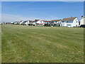
Houses on Marine Drive
Above Bull Cliff
Image: © Eirian Evans
Taken: 23 Jun 2021
0.13 miles
2
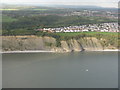
Bull Cliff, Barry
Looking across to houses at Westward Corner.
Image: © M J Richardson
Taken: 4 Oct 2010
0.13 miles
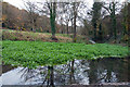
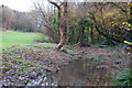
5
Porthkerry Country Park, Barry
Pool and its feeder stream overflow at bottom of access road.
Image: © Mick Lobb
Taken: 23 Nov 2010
0.18 miles
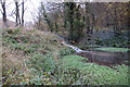
6
Porthkerry Country Park, Barry
Stream and pool to be found at the bottom of the hill leading down to the park. The stream then passes beneath the road to form a larger pool before spilling over a dam to continue to the sea.
Image: © Mick Lobb
Taken: 23 Nov 2010
0.19 miles
7
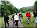
Parc Gwledig Porthceri / Porthkerry Country Park
Cerddwyr ym Mharc Gwledig Porthceri yn mynd i gyfeiriad y Bari
Walkers in Porthkerry Country Park heading in the direction of Barry.
Image: © Alan Richards
Taken: 3 Jun 2007
0.19 miles
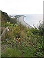
8
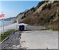
Western end of Knap Car Terrace, Barry
The red sign on the left shows BEWARE OF FALLING ROCKS. At the early March 2013 date of this view, vehicular access ended at this http://www.geograph.org.uk/photo/3966004 barrier about 50 metres behind the camera.
Image: © Jaggery
Taken: 5 Mar 2013
0.20 miles
9
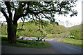
Oak tree & car park, Porthkerry Country Park
Coeden derwen a maes parcio, Park Gwledig Porthceri
Image: © Christopher R Ware
Taken: 5 May 2007
0.20 miles
10
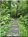
Woodland steps
Steps down into Cwm Barri and Porthkerry Park.
Image: © Alan Hughes
Taken: 3 May 2022
0.21 miles