1
Northern end of Clive Place, Barry Island
Viewed along Clive Road. The cars are parked in Clive Place.
The fence is at the perimeter of Barry docks.
Image: © Jaggery
Taken: 30 Dec 2012
0.01 miles
2
Clive Place, Barry Island
Viewed from the corner of Phyllis Street looking along Clive Place towards the corner of Clive Road.
Image: © Jaggery
Taken: 30 Dec 2012
0.01 miles
3
Ordnance Survey Cut Mark
This OS cut mark can be found on No1 Clive Road. It marks a point 28.666m above mean sea level.
Image: © Adrian Dust
Taken: 11 Mar 2018
0.01 miles
4
Clive Place, Barry Island
The Docks Office can be seen in the distance.
Image: © John Lord
Taken: 22 Mar 2011
0.03 miles
5
Dock Road, Barry Island
Dock Road descends past flats in The Triangle. http://www.geograph.org.uk/photo/3278254
Signs show that this is the way to the Pilot Station and the RNLI premises (Lifeboat Station).
Image: © Jaggery
Taken: 30 Dec 2012
0.03 miles
6
The Triangle, Barry Island
This is part of the area known as The Triangle, at the junction of Clive Place on the left of the central (flats) building and Dock Road on the right side of the building. The road on the camera side is Plymouth Road on the left and Redbrink Crescent on the right.
Image: © Jaggery
Taken: 30 Dec 2012
0.03 miles
7
Phyllis St, Barry Island, near the junction with Clive Place
Image: © John Lord
Taken: 22 Mar 2011
0.03 miles
8
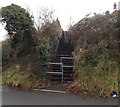
Flight of steps, Dock Road, Barry Island
The steps ascend from Dock Road to Dyfrig Street.
Image: © Jaggery
Taken: 30 Dec 2012
0.03 miles
9
20mph speed limit on Dock Road, Barry Island
Dock Road descends from The Triangle http://www.geograph.org.uk/photo/3278254 past a flight of steps on the right. http://www.geograph.org.uk/photo/3278330 The notice states that there is no access ahead to the main port estate. The Cadoxton entrance is open 24 hours.
Image: © Jaggery
Taken: 30 Dec 2012
0.04 miles
10
Clive Road east of Ivor Street, Barry Island
Clive Road houses are all on one side of the street.
On the opposite side is a boundary fence at the edge of Barry docks.
Image: © Jaggery
Taken: 30 Dec 2012
0.04 miles


