1
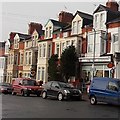
Clive Road east of Ivor Street, Barry Island
Clive Road houses are all on one side of the street.
On the opposite side is a boundary fence at the edge of Barry docks.
Image: © Jaggery
Taken: 30 Dec 2012
0.01 miles
2
Allotment Sheds, Barry Island
The docks are hidden behind the hedge. Beyond them is Morrison's Supermarket and new housing built on the old rail yards serving the coaling stations.
The 'rugby posts' on the left are the bridge over the railway.
Image: © Guy Butler-Madden
Taken: 3 Sep 2013
0.02 miles
3
Ordnance Survey Cut Mark
This OS cut mark can be found on No1 Clive Road. It marks a point 28.666m above mean sea level.
Image: © Adrian Dust
Taken: 11 Mar 2018
0.03 miles
4
Clive Place, Barry Island
Viewed from the corner of Phyllis Street looking along Clive Place towards the corner of Clive Road.
Image: © Jaggery
Taken: 30 Dec 2012
0.05 miles
5
Northern end of Clive Place, Barry Island
Viewed along Clive Road. The cars are parked in Clive Place.
The fence is at the perimeter of Barry docks.
Image: © Jaggery
Taken: 30 Dec 2012
0.05 miles
6
Phyllis St, Barry Island, near the junction with Clive Place
Image: © John Lord
Taken: 22 Mar 2011
0.05 miles
7
Eastern end of Phyllis Street, Barry Island
Viewed from Clive Place. Phyllis Street was named after a daughter of the Earl of Plymouth,
who was a major landowner in Barry at the end of the 19th and start of the 20th century.
Image: © Jaggery
Taken: 30 Dec 2012
0.05 miles
8
The Triangle, Barry Island
This is part of the area known as The Triangle, at the junction of Clive Place on the left of the central (flats) building and Dock Road on the right side of the building. The road on the camera side is Plymouth Road on the left and Redbrink Crescent on the right.
Image: © Jaggery
Taken: 30 Dec 2012
0.06 miles
9
Clive Place, Barry Island
The Docks Office can be seen in the distance.
Image: © John Lord
Taken: 22 Mar 2011
0.07 miles
10
Barry Island post office
Barry Island post office is inside this Costcutter store at 6 Plymouth Road.
Image: © Jaggery
Taken: 30 Dec 2012
0.07 miles


