IMAGES TAKEN NEAR TO
Friars Road, BARRY, CF62 5UB
Introduction
This page details the photographs taken nearby to Friars Road, CF62 5UB by members of the Geograph project.
The Geograph project started in 2005 with the aim of publishing, organising and preserving representative images for every square kilometre of Great Britain, Ireland and the Isle of Man.

There are currently over 7.5m images from over14,400 individuals and you can help contribute to the project by visiting https://www.geograph.org.uk
Image Map
Images are licensed for reuse under creativecommons.org/licenses/by-sa/2.0
Notes
- Clicking on the map will re-center to the selected point.
- The higher the marker number, the further away the image location is from the centre of the postcode.
Image Listing (118 Images Found)
Images are licensed for reuse under creativecommons.org/licenses/by-sa/2.0
Image
Details
Distance
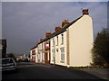
1
The Marine, Barry Island
Large pub on the corner of Plymouth Road and Friars Road.
Image: © Jaggery
Taken: 30 Dec 2012
0.02 miles
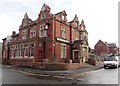
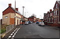
2
The Triangle, Barry Island
This is part of the area known as The Triangle, at the junction of Clive Place on the left of the central (flats) building and Dock Road on the right side of the building. The road on the camera side is Plymouth Road on the left and Redbrink Crescent on the right.
Image: © Jaggery
Taken: 30 Dec 2012
0.02 miles
3
Barry Island post office
Barry Island post office is inside this Costcutter store at 6 Plymouth Road.
Image: © Jaggery
Taken: 30 Dec 2012
0.03 miles

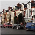
5
Phyllis St, Barry Island, near the junction with Clive Place
Image: © John Lord
Taken: 22 Mar 2011
0.03 miles
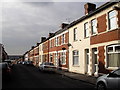
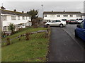
6
Clive Place, Barry Island
The Docks Office can be seen in the distance.
Image: © John Lord
Taken: 22 Mar 2011
0.03 miles
7
Western end of Redbrink Crescent, Barry Island
Viewed from the edge of The Triangle. http://www.geograph.org.uk/photo/3278254 Redbrink Crescent takes its make from Redbrink Point,
a nearby coastal area where the cliffs have strata of reddish rocks.
Image: © Jaggery
Taken: 30 Dec 2012
0.05 miles
8
NE end of Earl Crescent, Barry Island
Earl Crescent is a cul-de-sac on the NE side of Friars Road.
Image: © Jaggery
Taken: 30 Dec 2012
0.05 miles
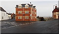
9
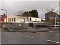
Corner of Friars Road and Earl Crescent, Barry Island
The large building on the left is Barry Island Community Centre.
Image: © Jaggery
Taken: 30 Dec 2012
0.05 miles
10

Blocked off western portal to the tunnel to the former Barry Pier railway station
The c250 metre long tunnel formerly led to Barry Pier railway station, which closed in the 1970s.
The station was about 750 metres east of the present-day end of the line at Barry Island station.
Image: © Jaggery
Taken: 30 Dec 2012
0.06 miles