IMAGES TAKEN NEAR TO
Higher End, BARRY, CF62 4LW
Introduction
This page details the photographs taken nearby to Higher End, CF62 4LW by members of the Geograph project.
The Geograph project started in 2005 with the aim of publishing, organising and preserving representative images for every square kilometre of Great Britain, Ireland and the Isle of Man.

There are currently over 7.5m images from over14,400 individuals and you can help contribute to the project by visiting https://www.geograph.org.uk
Image Map
Images are licensed for reuse under creativecommons.org/licenses/by-sa/2.0
Notes
- Clicking on the map will re-center to the selected point.
- The higher the marker number, the further away the image location is from the centre of the postcode.
Image Listing (14 Images Found)
Images are licensed for reuse under creativecommons.org/licenses/by-sa/2.0
Image
Details
Distance
1
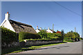
Myrtle Cottage, Higher End - St Athan
An 18th/19th century thatched cottage, a rare example of its kind in the area. Records show that to the rear of the cottage there is a smalle outbuilding that was, at one time, the village cobblers shop.
Image: © Mick Lobb
Taken: 7 Aug 2009
0.01 miles
3
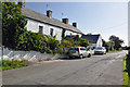
West Orchard Farmhouse, Higher End - St Athan
Having mainly 19th century features but of C17 origin with one remaining Tudor-arched doorway. The building is a two-storey rubble cream-washed house
with a slate roof and gabled porch.
Image: © Mick Lobb
Taken: 7 Aug 2009
0.05 miles
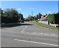
5
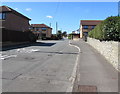
West along Llantwit Road, St Athan
Viewed from the corner of Rectory Road.
Image: © Jaggery
Taken: 17 Sep 2019
0.18 miles
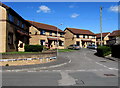
6
Warlow Close, St Athan
Cul-de-sac on the south side of Llantwit Road.
Image: © Jaggery
Taken: 17 Sep 2019
0.18 miles
7
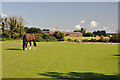
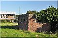
Paddock, Higher End - St Athan
In the background a hangar and water tower on the site of the airfield.
Image: © Mick Lobb
Taken: 7 Aug 2009
0.19 miles
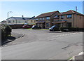
8
Llantwit Gardens Close, St Athan
Cul-de-sac on the north side of Llantwit Road.
Image: © Jaggery
Taken: 17 Sep 2019
0.19 miles
9
St John's View, St Athan
Cul-de-sac on the west side of Cowbridge Road.
Image: © Jaggery
Taken: 17 Sep 2019
0.20 miles
10
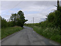
Lane near Sain Tathan (St Athan) village
The sprawling RAF St Athan is to the left (North) of this apparently rural location.
Image: © John Martin
Taken: 13 May 2007
0.21 miles