IMAGES TAKEN NEAR TO
Ffordd Y Spitfire, CF62 4HN
Introduction
This page details the photographs taken nearby to Ffordd Y Spitfire, CF62 4HN by members of the Geograph project.
The Geograph project started in 2005 with the aim of publishing, organising and preserving representative images for every square kilometre of Great Britain, Ireland and the Isle of Man.

There are currently over 7.5m images from over14,400 individuals and you can help contribute to the project by visiting https://www.geograph.org.uk
Image Map (Loading...)


Getting Data...Please wait
Leaflet Map data © OpenStreetMap
Images are licensed for reuse under creativecommons.org/licenses/by-sa/2.0
Notes
- Clicking on the map will re-center to the selected point.
- The higher the marker number, the further away the image location is from the centre of the postcode.
Image Listing (20 Images Found)
Images are licensed for reuse under creativecommons.org/licenses/by-sa/2.0
Image
Details
Distance
1
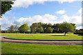
Sergeant's Mess, RAF St Athan
Well it was, up until around five years ago although the building is still shown on the maps - including Google!
There were two messes for senior NCO's on the site, one served the School of Technical Training and the other, still in existence inside the confines of what is now an MOD establishment, that served the Maintenance Unit. There was some element of choice however because some of the staff working on the west side of camp were housed on the east according to the availability of accommodation for married personnel.
Image: © Mick Lobb
Taken: 3 May 2009
0.06 miles
2
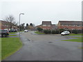
Part of a close in St. Athan village
Quiet little cul-de-sac or close.
Image: © Jeremy Bolwell
Taken: 19 Feb 2017
0.07 miles
3
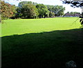
Sunshine and shadow on private land, Eglwys Brewis, Vale of Glamorgan
Viewed from near these https://www.geograph.org.uk/photo/6265620 private property notices.
Image: © Jaggery
Taken: 13 Sep 2019
0.08 miles
4
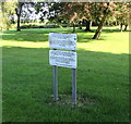
Private Property notices facing Cowbridge Road, Eglwys Brewis, Vale of Glamorgan
The upper notice states that this is private property and there is no public access or right of way without the permission of the owner. The owner hereby permits access by members of the public onto the land for recreational purposes only at their own risk. This permission may be revoked at any time.
The text on the lower notice is in Welsh.
Image: © Jaggery
Taken: 13 Sep 2019
0.09 miles
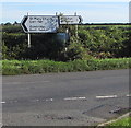
5
Bi-lingual sign at Eglwys Brewis (Brewys)!
Image: © Mick Lobb
Taken: 23 Jun 2008
0.11 miles
6
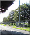
Telecoms mast alongside Cowbridge Road, Eglwys Brewis
Another mast https://www.geograph.org.uk/photo/6283779 is in the background.
Image: © Jaggery
Taken: 13 Sep 2019
0.11 miles
7
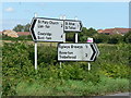
Direction and distances signs, Cowbridge Road, Eglwys Brewis, Vale of Glamorgan
In the background here. https://www.geograph.org.uk/photo/6265559
Left along St Athan Road for St Mary Church (2 miles) and Cowbridge (4).
Right along Cowbridge Road for St Athan (1 mile). The Welsh names are also shown.
Image: © Jaggery
Taken: 13 Sep 2019
0.13 miles
8

Rear view of The Gathering Place, St Athan
This was once the location of one of two Sergeant's Messes on the former RAF station. This, along with much of the past heritage of the site is in the process of disappearing. The Gathering Place is a Methodist Church & Community Facility serving as a spiritual and social centre for the area.
Image: © Mick Lobb
Taken: 23 Jun 2008
0.13 miles
9
Junction in Eglwys Brewis, Vale of Glamorgan
Viewed across Eglwys Brewis Road. St Athan Road is on the left, Cowbridge Road on the right.
Image: © Jaggery
Taken: 13 Sep 2019
0.13 miles
10
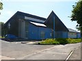
Front view of The Gathering Place, St Athan
This was once the location of one of two Sergeant's Messes on the former RAF station. This, along with much of the past heritage of the site is in the process of disappearing. The Gathering Place is a Methodist Church & Community Facility serving as a spiritual and social centre for the area.
Image: © Mick Lobb
Taken: 23 Jun 2008
0.14 miles