IMAGES TAKEN NEAR TO
CF6 1DE
Introduction
This page details the photographs taken nearby to CF6 1DE by members of the Geograph project.
The Geograph project started in 2005 with the aim of publishing, organising and preserving representative images for every square kilometre of Great Britain, Ireland and the Isle of Man.

There are currently over 7.5m images from over14,400 individuals and you can help contribute to the project by visiting https://www.geograph.org.uk
Image Map
Images are licensed for reuse under creativecommons.org/licenses/by-sa/2.0
Notes
- Clicking on the map will re-center to the selected point.
- The higher the marker number, the further away the image location is from the centre of the postcode.
Image Listing (164 Images Found)
Images are licensed for reuse under creativecommons.org/licenses/by-sa/2.0
Image
Details
Distance
1
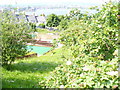
On Penarth Head
Looking from viewpoint, over a children's play area, to rooftops of houses on the south side of Penarth Flats.
Image: © Colin Smith
Taken: 7 Jun 2008
0.03 miles
2
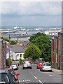
Stanwell Crescent, Penarth
Looking towards the Port of Cardiff.
Image: © Gareth James
Taken: 9 Jun 2010
0.04 miles
3
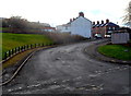
Stanwell Crescent, Penarth
Stanwell Crescent climbs away from the junction of John Street, Queens Road and Maugham Terrace.
Image: © Jaggery
Taken: 9 Dec 2012
0.05 miles
4

Stanwell Crescent, not to mention the hill, Penarth
Cardiff Bay can be seen in the background.
Image: © Ruth Sharville
Taken: 20 Sep 2021
0.05 miles
5
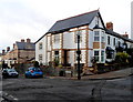
Belle Vue Terrace, Penarth
Belle Vue Terrace is on the left, St Augustine's Place on the right.
Image: © Jaggery
Taken: 9 Dec 2012
0.05 miles
6
Ordnance Survey Cut Mark
This OS cut mark can be found on No7 Stanwell Crescent. It marks a point 51.978m above mean sea level.
Image: © Adrian Dust
Taken: 25 Sep 2017
0.06 miles
8
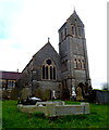
West side of St Augustine's Church Penarth
Viewed from St Augustine's Place. The church was completed in 1866, designed by the Victorian architect William Butterfield. The building cost £10,000, financed by the Countess of Plymouth.
It replaced a smaller church on this site. Grade I listed (the highest category) in 1989.
Image: © Jaggery
Taken: 9 Dec 2012
0.06 miles
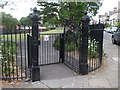
9
Belle Vue Park, Penarth
This is the NE corner of the triangular park, viewed from the Belle Vue Terrace entrance.
Image: © Jaggery
Taken: 9 Dec 2012
0.06 miles
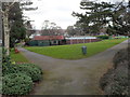
10
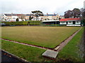
Belle Vue Park Bowling Green, Penarth
The bowling green was created in 1915 on the site of a disused quarry (shown on 1870s Ordnance Survey maps). It is inside Belle Vue Park, which was officially opened on May 22nd 1915.
Image: © Jaggery
Taken: 9 Dec 2012
0.07 miles