IMAGES TAKEN NEAR TO
Llanmaes Road, LLANTWIT MAJOR, CF61 2XD
Introduction
This page details the photographs taken nearby to Llanmaes Road, CF61 2XD by members of the Geograph project.
The Geograph project started in 2005 with the aim of publishing, organising and preserving representative images for every square kilometre of Great Britain, Ireland and the Isle of Man.

There are currently over 7.5m images from over14,400 individuals and you can help contribute to the project by visiting https://www.geograph.org.uk
Image Map
Images are licensed for reuse under creativecommons.org/licenses/by-sa/2.0
Notes
- Clicking on the map will re-center to the selected point.
- The higher the marker number, the further away the image location is from the centre of the postcode.
Image Listing (208 Images Found)
Images are licensed for reuse under creativecommons.org/licenses/by-sa/2.0
Image
Details
Distance
1
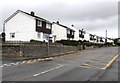
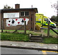
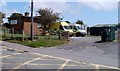
Detached houses, Llanmaes Road, Llantwit Major
Viewed across the yellow Keep Clear Zone near the town's fire station and ambulance station.
Image: © Jaggery
Taken: 25 Sep 2019
0.01 miles
2
Up Windmill Lane, Llantwit Major
Windmill Lane ascends away from the Llanmaes Road junction.
The Windmill Close junction https://www.geograph.org.uk/photo/6277531 is ahead on the left.
Image: © Jaggery
Taken: 25 Sep 2019
0.03 miles
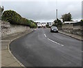
3
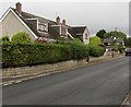
Houses on the east side of Windmill Lane, Llantwit Major
Semi-detached houses viewed from the corner of Windmill Close.
Image: © Jaggery
Taken: 25 Sep 2019
0.03 miles
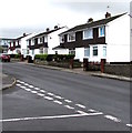
4
Llanmaes Road houses, Llantwit Major
Viewed from the edge of the fire station. http://www.geograph.org.uk/photo/3176366
Image: © Jaggery
Taken: 9 Jul 2011
0.04 miles
5
Bilingual nameboard on the wall of Llantwit Major ambulance station
The board on the left here https://www.geograph.org.uk/photo/6277655 shows that LLANTWIT MAJOR AMBULANCE STATION is GORSAF AMBIWLANS LLANILLTAD FAWR. LLANILLTAD is a typo. It should be LLANILLTUD.
Image: © Jaggery
Taken: 25 Sep 2019
0.04 miles
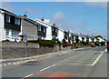
6
West side of Windmill Lane, Llantwit Major
The broken white lines on the left are at the Windmill Close junction. https://www.geograph.org.uk/photo/6277531
Image: © Jaggery
Taken: 25 Sep 2019
0.04 miles
7
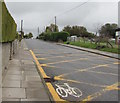
Yellow rectangle painted on Llanmaes Road, Llantwit Major
Marking the Keep Clear Zone outside the town's fire station and ambulance station.
Image: © Jaggery
Taken: 25 Sep 2019
0.04 miles
8

Entrance to Llantwit Major ambulance station
From Llanmaes Road. A 5 mph speed limit sign is on the right.
Image: © Jaggery
Taken: 25 Sep 2019
0.04 miles
9
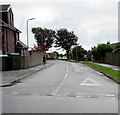
Fairfield Rise, Llantwit Major
Road on the southeast side of Llanmaes Road. A dark green telecoms cabinet is on the left.
Image: © Jaggery
Taken: 25 Sep 2019
0.04 miles
10
Llantwit Major ambulance station
Located on the south side of Llanmaes Road, next door to the fire station. http://www.geograph.org.uk/photo/3176366
Image: © Jaggery
Taken: 9 Jul 2011
0.05 miles