1
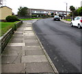
Bedford Road houses, Llantwit Major
Houses on the south side of Bedford Rise west of the Grey's Drive junction.
Image: © Jaggery
Taken: 25 Sep 2019
0.05 miles
2
Bend in Bedford Rise, Llantwit Major
Viewed from the corner of Eagleswell Road. The corner of Grey's Drive is ahead on the left.
Image: © Jaggery
Taken: 25 Sep 2019
0.07 miles
3
Ordnance Survey Cut Mark
This OS cut mark can be found on the wall north side of the road. It marks a point 33.107m above mean sea level.
Image: © Adrian Dust
Taken: 6 Sep 2022
0.08 miles
4
Windsor Close, Llantwit Major
Image: © Mick Lobb
Taken: 5 Jan 2009
0.09 miles
5
Entering Boverton from the west
Development of the nearby airfield, now in the penultimate stages of its long and useful life as a military base, promoted expansion of the village and nearby Llantwit Major to the extent that their borders seem no longer to exist. Such is the case now when more and more people seek land to live on with the result that there will no longer be enough available to meet their basic need for agricultural use. To the right of the village sign a speed warning device that has replaced the speed trap camera that was a short lived attempt to slow traffic - prosaically beside the local cemetery.
Image: © Mick Lobb
Taken: 26 Feb 2011
0.09 miles
6
Grey's Drive, Llantwit Major
Cul-de-sac on the SE side of Bedford Rise.
Image: © Jaggery
Taken: 25 Sep 2019
0.09 miles
7
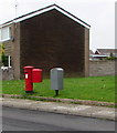
Two Royal Mail drop boxes, Bedford Rise, Llantwit Major
A grey drop box is alongside a smaller red drop box attached to a pillarbox.
I cannot recall seeing two Royal Mail drop boxes together before.
Image: © Jaggery
Taken: 25 Sep 2019
0.10 miles
8
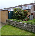
Bedford Rise electricity substation, Llantwit Major
Western Power Distribution electricity substation on the east side of Bedford Rise between Grey's Drive and Eagleswell Road. The substation identifier is BEDFORD RISE S/S 563031
Image: © Jaggery
Taken: 25 Sep 2019
0.10 miles
9
Town sign, Boverton Road - Llantwit Major
Image: © Mick Lobb
Taken: 8 Mar 2010
0.11 miles
10
Unnamed side road in suburban Llantwit Major
On the west side of Eagleswell Road near De Clare Court. https://www.geograph.org.uk/photo/6278452
Image: © Jaggery
Taken: 25 Sep 2019
0.11 miles


