IMAGES TAKEN NEAR TO
Castle Close, LLANTWIT MAJOR, CF61 1UU
Introduction
This page details the photographs taken nearby to Castle Close, CF61 1UU by members of the Geograph project.
The Geograph project started in 2005 with the aim of publishing, organising and preserving representative images for every square kilometre of Great Britain, Ireland and the Isle of Man.

There are currently over 7.5m images from over14,400 individuals and you can help contribute to the project by visiting https://www.geograph.org.uk
Image Map
Images are licensed for reuse under creativecommons.org/licenses/by-sa/2.0
Notes
- Clicking on the map will re-center to the selected point.
- The higher the marker number, the further away the image location is from the centre of the postcode.
Image Listing (67 Images Found)
Images are licensed for reuse under creativecommons.org/licenses/by-sa/2.0
Image
Details
Distance
1
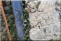
Ordnance Survey Cut Mark
This OS cut mark can be found on the barn NE side of the road. It marks a point 44.114m above mean sea level.
Image: © Adrian Dust
Taken: 11 Mar 2018
0.06 miles
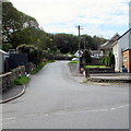
3
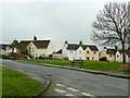
Housing at Boverton/Trebeferad
Looking south-west from the junction with Mill Lane.
Image: © Jonathan Billinger
Taken: 23 Mar 2010
0.08 miles
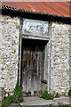
4
Boverton Place
Now a romantic ruin, but at one time the home of the Attourney General for Wales, see Image
Image: © Jonathan Billinger
Taken: 23 Mar 2010
0.12 miles
5
Tre-beferad Road, Boverton
This part of Tre-beferad Road is southwest of the Redwood Close junction.
Image: © Jaggery
Taken: 25 Sep 2019
0.12 miles
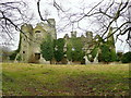
6
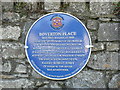
History plaque on wall at Boverton Place.
The ruins are widely known as 'Boverton Castle', 'Boverton Manor' but now its true identity is revealed.
Image: © Mick Lobb
Taken: 13 Sep 2008
0.13 miles

8
SW along Tre-beferad Road, Boverton
Viewed across Boverton Road. Tre-beferad (or Trebeferad) is the Welsh name for Boverton.
Image: © Jaggery
Taken: 25 Sep 2019
0.15 miles
9
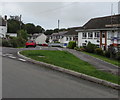
Redwood Close, Boverton
Cul-de-sac viewed across Tre-beferad Road 85 metres SW of Boverton Road.
Image: © Jaggery
Taken: 25 Sep 2019
0.15 miles
10
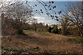
Footpath beside the Hoddnant - Boverton
The footpath follows the river from south of the village to turn northwest away from it to pass the local cemetery. In summer the area of scrub becomes a tangled mass of vegetation. The river is located just below the houses on the right and follows the line of the trees.
Image: © Mick Lobb
Taken: 26 Feb 2011
0.15 miles