IMAGES TAKEN NEAR TO
Colhugh Street, LLANTWIT MAJOR, CF61 1UG
Introduction
This page details the photographs taken nearby to Colhugh Street, CF61 1UG by members of the Geograph project.
The Geograph project started in 2005 with the aim of publishing, organising and preserving representative images for every square kilometre of Great Britain, Ireland and the Isle of Man.

There are currently over 7.5m images from over14,400 individuals and you can help contribute to the project by visiting https://www.geograph.org.uk
Image Map
Images are licensed for reuse under creativecommons.org/licenses/by-sa/2.0
Notes
- Clicking on the map will re-center to the selected point.
- The higher the marker number, the further away the image location is from the centre of the postcode.
Image Listing (411 Images Found)
Images are licensed for reuse under creativecommons.org/licenses/by-sa/2.0
Image
Details
Distance
1
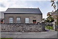
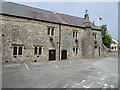
Tabernacle, Calvinistic Methodist Chapel, Llantwit Major
Image: © Mick Lobb
Taken: 29 Apr 2009
0.03 miles
2
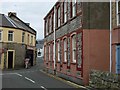
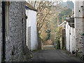
Llantwit Major
The northern end of Colhugh Street, where it joins Church Street.
Image: © Stephen McKay
Taken: 15 Dec 2006
0.03 miles
3
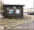
Public toilets near Church Street, Llantwit Major
In the northeast corner of a car park.
Image: © Jaggery
Taken: 5 Nov 2019
0.04 miles
4
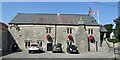
Llantwit Major - Town Hall
Llantwit Major is a small historic market town in the Vale of Glamorgan. The old Town Hall dates back to the 15th century.
www.llantwitmajortowncouncil.gov.uk
Image: © Colin Smith
Taken: 31 Aug 2018
0.04 miles
6
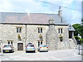
Burial Lane, Llantwit Major
The lane is to the rear of Church Street that leads down to the church. Was it so named because of someone's macabre sense of humour or did burial parties use the lane to lessen the impact of such sobering events on the townsfolk in carrying their sad burden down the street I wonder.
Information update:
'Ceridwen' suggests that Burial Lane may be what is also known as a corpse, or coffin, road. This was the route that a coffin would be carried for burial from an outlying part of the parish, often over a considerable distance. From the map, it might be the case that one of the footpaths marked as leading towards the village was also part of the route, possibly more direct than following the road.
Image: © Mick Lobb
Taken: 9 Jan 2009
0.04 miles
7
Historic Llantwit Major
Ancient Christian settlement with roots dating back to 500AD. This old stone hall house has an outer double staircase.
Image: © Colin Smith
Taken: 18 Jul 2009
0.05 miles
8
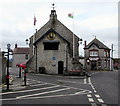
Llantwit Major town hall
Located at the eastern end of Burial Lane. The Tudor Tavern is on the right.
A blue plaque http://www.geograph.org.uk/photo/3178824 on the building records that this was a Norman manorial courthouse for the holding of courts leet (tenants) and baron (freeholders) for the manor of Boverton and Llantwit Major. It was rebuilt under the lordship of Jasper Tudor (1485-1495); became a guildhall in the time of Henry VIII, then the bailiff's house. It was then leased in part to the St. Illtyd's lodge of the Oddfellows Society in 1845 and taken over by the first parish council in 1894.
In early April 2015, a board at the entrance shows VISITOR INFORMATION INSIDE.
Image: © Jaggery
Taken: 3 Apr 2015
0.05 miles
9

E-Type Jaguar
An E-Type Jaguar, an iconic British car parked in a car park in Llantwit Major.
Image: © Philip Halling
Taken: 14 Jun 2021
0.05 miles
10

E-Type Jaguar
An E-Type Jaguar, an iconic British car parked in a car park in Llantwit Major.
Image: © Philip Halling
Taken: 14 Jun 2021
0.05 miles