IMAGES TAKEN NEAR TO
River Walk, LLANTWIT MAJOR, CF61 1SY
Introduction
This page details the photographs taken nearby to River Walk, CF61 1SY by members of the Geograph project.
The Geograph project started in 2005 with the aim of publishing, organising and preserving representative images for every square kilometre of Great Britain, Ireland and the Isle of Man.

There are currently over 7.5m images from over14,400 individuals and you can help contribute to the project by visiting https://www.geograph.org.uk
Image Map
Images are licensed for reuse under creativecommons.org/licenses/by-sa/2.0
Notes
- Clicking on the map will re-center to the selected point.
- The higher the marker number, the further away the image location is from the centre of the postcode.
Image Listing (403 Images Found)
Images are licensed for reuse under creativecommons.org/licenses/by-sa/2.0
Image
Details
Distance
1
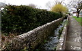
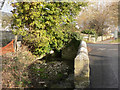
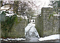
Ogney Brook flows through a channel alongside River Walk, Llantwit Major
Emerging from a culvert in the distance, the brook flows along a channel on the west side of the exaggeratedly named River Walk. This water enters the Bristol Channel at Llantwit Beach via Afon Col-huw which is also known as River Colhuw or River Colhugh.
Image: © Jaggery
Taken: 3 Apr 2015
0.02 miles
2
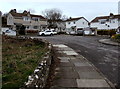
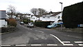
River Walk turning circle, Llantwit Major
This part of River Walk is a cul-de-sac on the north side of the Westhill Street and Wine Street junction.
The stone wall is at the edge of Ogney Brook.
Image: © Jaggery
Taken: 3 Apr 2015
0.02 miles
3
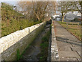
Ogney Brook at River Walk, Llantwit Major
The brook was constrained between walls here when the houses were built.
Image: © Mick Lobb
Taken: 9 Jan 2009
0.03 miles
4
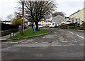
River Walk, Llantwit Major
Cul-de-sac on the north side of the Westhill Street and Wine Street junction.
Brook Walk would be a better name - below the wall on the left flows Ogney Brook.
Image: © Jaggery
Taken: 3 Apr 2015
0.03 miles
5
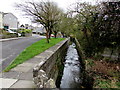
Ogney Brook, Llantwit Major
The Ogney Brook returns to its natural form on leaving River Walk.
Image: © Mick Lobb
Taken: 9 Jan 2009
0.03 miles
6
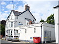
Llantwit Major Police Station
Large building which still carries the words "County Police Station 1928". Those days were not bilingual as far as signs were concerned.
Image: © Colin Smith
Taken: 18 Jul 2009
0.04 miles
8
Castle Court, Llantwit Major
Cul-de-sac on the east side of West Street, opposite The Ruins http://www.geograph.org.uk/photo/4413129
(or Old Place or (inaccurately) Llantwit Major Castle).
Image: © Jaggery
Taken: 3 Apr 2015
0.04 miles
9
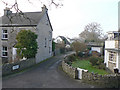
Alley off West Street, Llantwit Major
The alley leads down to River Walk and Wine Street.
Image: © Mick Lobb
Taken: 3 Feb 2009
0.04 miles
10
Ogney Brook alongside River Walk, Llantwit Major
Ogney Brook emerges from a culvert and flows along a channel on the west side of the exaggeratedly named River Walk.
Image: © Jaggery
Taken: 3 Apr 2015
0.04 miles