IMAGES TAKEN NEAR TO
Bonvilston, CARDIFF, CF5 6TU
Introduction
This page details the photographs taken nearby to CF5 6TU by members of the Geograph project.
The Geograph project started in 2005 with the aim of publishing, organising and preserving representative images for every square kilometre of Great Britain, Ireland and the Isle of Man.

There are currently over 7.5m images from over14,400 individuals and you can help contribute to the project by visiting https://www.geograph.org.uk
Image Map
Images are licensed for reuse under creativecommons.org/licenses/by-sa/2.0
Notes
- Clicking on the map will re-center to the selected point.
- The higher the marker number, the further away the image location is from the centre of the postcode.
Image Listing (14 Images Found)
Images are licensed for reuse under creativecommons.org/licenses/by-sa/2.0
Image
Details
Distance
1
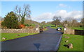
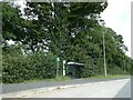
Entrance drive to Cottrell Park Golf Resort
Viewed from the edge of the A48.
The Cottrell Estate was purchased in 1942 by the present owners, William Powell & Sons. Before construction of the golf course, the land was used for agriculture. The manor house was demolished in 1972, as it had become unfit for habitation. Three properties remaining on the site have been renovated for staff accommodation.
Cottrell Park Golf Resort has two 18-hole courses. One is the Mackintosh course, named after Alfred Donald Mackintosh of Mackintosh, the 28th Chief of Clan Mackintosh and Chief of Clan Chattan, who lived at Cottrell Park in the late 19th and early 20th centuries. The course is 6,313 yards long.
The other is the Button Gwinnett Course, named after the Button family who lived at Cottrell Park during the 17th century. The course is 6,183 yards long.
Image: © Jaggery
Taken: 27 Jan 2012
0.12 miles
2
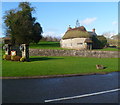
Cottrell Lodge west of St Nicholas
Formerly the lodge of Cottrell House, the thatched cottage is adjacent to the entrance drive http://www.geograph.org.uk/photo/2781398 from the A48 to Cottrell Park Golf Resort.
Image: © Jaggery
Taken: 27 Jan 2012
0.14 miles
3
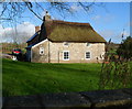
South side of Cottrell Lodge west of St Nicholas
Viewed from the edge of the A48. Formerly the lodge of Cottrell House, the thatched cottage is adjacent to the entrance drive http://www.geograph.org.uk/photo/2781398 from the A48 to Cottrell Park Golf Resort.
Image: © Jaggery
Taken: 27 Jan 2012
0.14 miles
4
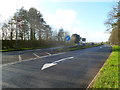
Eastern edge of dual carriage on the A48 near Bonvilston
Ahead, the westbound and eastbound carriageways of the A48 are separated by a metal barrier on a narrow grassy strip.
Image: © Jaggery
Taken: 27 Jan 2012
0.15 miles
6
Access road to Cottrell Park Golf Resort
Image: © David Smith
Taken: 18 Sep 2022
0.16 miles
7
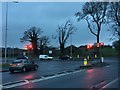
Sycamore Cross, Bonvilston
Recently installed traffic controls (2013) at Sycamore Cross, Bonvilston - on a murky December afternoon.
Image: © Alan Hughes
Taken: 14 Dec 2015
0.20 miles
8
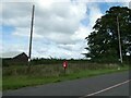
Postbox by A48 at Sycamore Cross
This isolated postbox is on a major road, and is close to a new housing estate on a side road; it has been sited for the convenience of postal collections
Image: © David Smith
Taken: 18 Sep 2022
0.20 miles
9
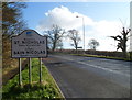
Western boundary of St Nicholas
The A48 reaches St Nicholas, a village in the Vale of Glamorgan. The similar sign on the A48 marking the eastern boundary of St Nicholas http://www.geograph.org.uk/photo/2781088 is about 1.5 km (nearly a mile) away.
Image: © Jaggery
Taken: 27 Jan 2012
0.20 miles
10
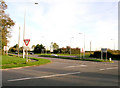
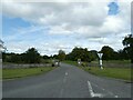
Sycamore Cross
A junction between the east / west A48 and the Five Mile Lane south to Barry and a minor road north to Pendoylan and the M4
Image: © Tony Hodge
Taken: 3 Nov 2006
0.22 miles