IMAGES TAKEN NEAR TO
Mawsons Mead, CARDIFF, CF5 6SX
Introduction
This page details the photographs taken nearby to Mawsons Mead, CF5 6SX by members of the Geograph project.
The Geograph project started in 2005 with the aim of publishing, organising and preserving representative images for every square kilometre of Great Britain, Ireland and the Isle of Man.

There are currently over 7.5m images from over14,400 individuals and you can help contribute to the project by visiting https://www.geograph.org.uk
Image Map
Images are licensed for reuse under creativecommons.org/licenses/by-sa/2.0
Notes
- Clicking on the map will re-center to the selected point.
- The higher the marker number, the further away the image location is from the centre of the postcode.
Image Listing (54 Images Found)
Images are licensed for reuse under creativecommons.org/licenses/by-sa/2.0
Image
Details
Distance
1

Church Hall House and Church Hall, St Nicholas
The house is on the right, the church hall is on the left, alongside the A48.
Image: © Jaggery
Taken: 27 Jan 2012
0.04 miles
2
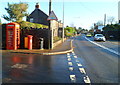
Phonebox and George V postbox, St Nicholas
Located alongside the A48 in the Vale of Glamorgan village of St Nicholas.
The postbox dates from the reign of King George V (1910-1936). Almost all of its black base seems to have sunk into the ground. Or it may be that resurfacings during several decades have raised the level of the pavement around the postbox.
Image: © Jaggery
Taken: 27 Jan 2012
0.04 miles
3

St. Nicholas Postbox and Telephone box
Located in the village of St. Nicholas, Vale of Glamorgan. An old red telephone box, now in use as a book repository, stands near a red, type B pillar box style postbox of the King George V era (1904 - 1936)
Image: © Emma M Baker
Taken: 24 Jul 2022
0.04 miles

5
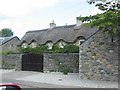
Thatched Cottage
In the village of St Nicholas
Image: © John Thorn
Taken: 28 Jul 2006
0.06 miles
6
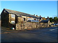
St Nicholas semis
Two semi-detached houses alongside the A48, facing the Duffryn Lane junction.
A lozenge above the doorway of the house on the right shows 1921.
Image: © Jaggery
Taken: 27 Jan 2012
0.06 miles
7
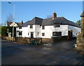
The Coach House, St Nicholas
Private residence alongside the A48, built as a coaching house c1815.
Image: © Jaggery
Taken: 27 Jan 2012
0.06 miles
8
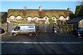
Grade II listed The Three Tuns, St Nicholas
Large thatched cottage alongside the A48. Dating from the 16th century, The Three Tuns was formerly an inn. Grade II listed in January 1963.
Image: © Jaggery
Taken: 27 Jan 2012
0.06 miles
9
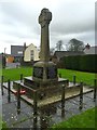
War Memorial
War Memorial in the village of St.Nicholas.
Image: © Alan Hughes
Taken: 4 Jan 2016
0.06 miles
10
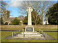
War memorial at St Nicholas in the Vale of Glamorgan
Image: © Mick Lobb
Taken: 10 Feb 2009
0.06 miles