IMAGES TAKEN NEAR TO
Grants Field, The Downs, CARDIFF, CF5 6SE
Introduction
This page details the photographs taken nearby to Grants Field, The Downs, CF5 6SE by members of the Geograph project.
The Geograph project started in 2005 with the aim of publishing, organising and preserving representative images for every square kilometre of Great Britain, Ireland and the Isle of Man.

There are currently over 7.5m images from over14,400 individuals and you can help contribute to the project by visiting https://www.geograph.org.uk
Image Map
Images are licensed for reuse under creativecommons.org/licenses/by-sa/2.0
Notes
- Clicking on the map will re-center to the selected point.
- The higher the marker number, the further away the image location is from the centre of the postcode.
Image Listing (19 Images Found)
Images are licensed for reuse under creativecommons.org/licenses/by-sa/2.0
Image
Details
Distance
1
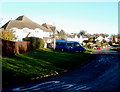
Grant's Field, The Downs
Houses on the north side of Grant's Field, the principal road through the hamlet of The Downs, Vale of Glamorgan.
Image: © Jaggery
Taken: 15 Nov 2010
0.03 miles
3
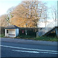
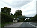
Partly-hidden postbox next to a footbridge, The Downs
Located between a footbridge across the A48 and a bus shelter is a postbox, easily missed. I suppose the thinking is that the box is mainly for use by locals, who know where it is...
Image: © Jaggery
Taken: 15 Nov 2010
0.04 miles
4
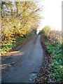
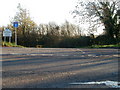
One-way lane to Grant's Field
Viewed from the edge of the A48. Traffic flow is one-way, away from the camera. The lane follows a 220-metre route due south to Grant's Field, the principal road in the hamlet of The Downs.
Image: © Jaggery
Taken: 15 Nov 2010
0.06 miles
5
Ordnance Survey Flush Bracket (G3716)
This OS Flush Bracket can be found on the wall SE side of Tumbledown. It marks a point 129.527m above mean sea level.
Image: © Adrian Dust
Taken: 26 Sep 2022
0.08 miles
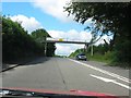
6
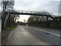
Footbridge over A48
Footbridge over A48 at the Downs above Culverhouse Cross.
Image: © Alan Hughes
Taken: 4 Jan 2016
0.09 miles
7
Footbridge over A48 at Downs. serving bus stop
Image: © David Smith
Taken: 19 Sep 2022
0.10 miles
8
The Downs Village
Secluded village just outside Cardiff
Image: © Christopher R Ware
Taken: 3 May 2007
0.10 miles
10
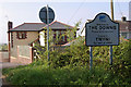
Entrance to The Downs hamlet
Viewed across the A48. The Downs is a hamlet between St Nicholas to the west and to the east, Culverhouse Cross at the western edge of Cardiff. The Welsh name for the hamlet is Y Mynydd. Strangely, this view http://www.geograph.org.uk/photo/421554 of another part of the hamlet shows the Welsh form as Twyni.
Image: © Jaggery
Taken: 15 Nov 2010
0.14 miles