IMAGES TAKEN NEAR TO
St. Fagans Drive, CARDIFF, CF5 6EF
Introduction
This page details the photographs taken nearby to St. Fagans Drive, CF5 6EF by members of the Geograph project.
The Geograph project started in 2005 with the aim of publishing, organising and preserving representative images for every square kilometre of Great Britain, Ireland and the Isle of Man.

There are currently over 7.5m images from over14,400 individuals and you can help contribute to the project by visiting https://www.geograph.org.uk
Image Map
Images are licensed for reuse under creativecommons.org/licenses/by-sa/2.0
Notes
- Clicking on the map will re-center to the selected point.
- The higher the marker number, the further away the image location is from the centre of the postcode.
Image Listing (158 Images Found)
Images are licensed for reuse under creativecommons.org/licenses/by-sa/2.0
Image
Details
Distance
1
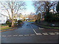
St Fagans Drive, St Fagans
Viewed across Crofft y Genau Road.
Image: © Jaggery
Taken: 17 Dec 2013
0.09 miles
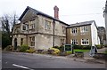
2
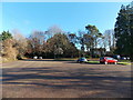
Car park near the village hall, St Fagans
Set back from the east side of Crofft y Genau Road.
Image: © Jaggery
Taken: 17 Dec 2013
0.09 miles
3
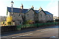
Row of 3 cottages, St Fagans
Viewed across Crofft y Genau Road.
Image: © Jaggery
Taken: 17 Dec 2013
0.10 miles
4
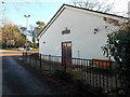
St Fagans Village Hall
Set back from the east side of Crofft y Genau Road, near the Plymouth Arms pub.
Image: © Jaggery
Taken: 17 Dec 2013
0.10 miles
5
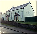
Former Tabernacle Presbyterian chapel, St Fagans
The inscription on the wall shows TABERNACLE PRESBYTERIAN and the years 1837 and 1900, presumably the year of construction and the year of a rebuild. Converted to residential use in 1989. Viewed across Crofft y Genau Road near the corner of Maes y Gad.
Image: © Jaggery
Taken: 17 Dec 2013
0.10 miles
7
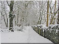
Restricted byway north of St Fagans
Heading downhill towards Pentrebane Road.
Image: © John Light
Taken: 19 Jan 2013
0.11 miles
8
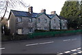
Clive Cottages, St Fagans
Row of 4 cottages alongside Crofft y Genau Road, opposite St Fagans Drive. http://www.geograph.org.uk/photo/3886417
Image: © Jaggery
Taken: 17 Dec 2013
0.11 miles
9
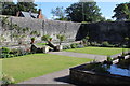
Italian Garden, St Fagans Castle
Enclosed formal garden in the grounds of the castle in St Fagans National History Museum. The wall in the background (left) marks the edge of the museum's grounds. The ornamental pond Image runs along the opposite stone wall.
Image: © M J Roscoe
Taken: 8 Sep 2016
0.12 miles
10
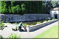
Pond, Italian Garden, St Fagans Castle
Ornamental pond in the Italian Garden of the castle in St Fagans National History Museum. The building in the background was known as the Enamel House, and houses an exhibition showing the history and restoration of the garden, completed in 2003.
Image: © M J Roscoe
Taken: 8 Sep 2016
0.12 miles