IMAGES TAKEN NEAR TO
Tarrws Close, CARDIFF, CF5 6BT
Introduction
This page details the photographs taken nearby to Tarrws Close, CF5 6BT by members of the Geograph project.
The Geograph project started in 2005 with the aim of publishing, organising and preserving representative images for every square kilometre of Great Britain, Ireland and the Isle of Man.

There are currently over 7.5m images from over14,400 individuals and you can help contribute to the project by visiting https://www.geograph.org.uk
Image Map
Images are licensed for reuse under creativecommons.org/licenses/by-sa/2.0
Notes
- Clicking on the map will re-center to the selected point.
- The higher the marker number, the further away the image location is from the centre of the postcode.
Image Listing (40 Images Found)
Images are licensed for reuse under creativecommons.org/licenses/by-sa/2.0
Image
Details
Distance
1
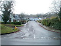
Southern arm of Gwenfo Drive, Wenvoe
Gwenfo Drive follows a course similar to an inverted U on the west side of Old Port Road. This view is along its southern arm, from the corner of Old Port Road. http://www.geograph.org.uk/photo/2167682 to houses along its northern arm.
Image: © Jaggery
Taken: 19 Nov 2010
0.05 miles
2
Northern arm of Gwenfo Drive, Wenvoe
Houses on the north side of the road, viewed across Old Port Road.
Gwenfo Drive follows a course similar to an inverted U on the west side of Old Port Road. http://www.geograph.org.uk/photo/2167688 to the southern arm.
Image: © Jaggery
Taken: 19 Nov 2010
0.10 miles
3
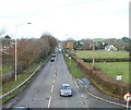
Port Road heading north, Wenvoe
The A4050 viewed from a footbridge. Here known as Port Road, the A4050 is effectively the Wenvoe bypass. It is about 100 metres east of the former trunk road, renamed Old Port Road, the main road through the residential part of the village.
Image: © Jaggery
Taken: 19 Nov 2010
0.11 miles
4
Primary school, Wenvoe
Gwenfo Church in Wales Primary School viewed from the footbridge across Port Road.
The buildings date from the 1970s. They replaced the original school which opened in 1861.
Image: © Jaggery
Taken: 19 Nov 2010
0.13 miles
5

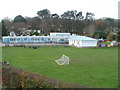
Wenvoe Village Hall
Located on the corner of Old Port Road and Station Road West, opposite the Community Centre. http://www.geograph.org.uk/photo/2167700
A committee of volunteers keep the Village Hall functioning smoothly and the building well maintained. This is done entirely by fund-raising and voluntary support. The Village Hall has been a venue for entertainment and activities for the villagers of Wenvoe and its neighbours since the late 1930s. Wenvoe Playgroup meet here every morning, Mondays - Fridays.
Image: © Jaggery
Taken: 19 Nov 2010
0.13 miles
6

Feeding time, Wenvoe
Two horses are feeding in a field bordered by Port Road and Station Road East, viewed from the eastern edge of a footbridge. At the far end of the field, a rather battered-looking former railway wagon is in use as a shed.
Image: © Jaggery
Taken: 19 Nov 2010
0.14 miles
7
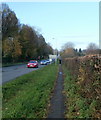
Jogger, Port Road, Wenvoe
A lunchtime jogger, clad in black, passes a road sign alongside a narrow footpath on the east side of Port Road (A4050).
Image: © Jaggery
Taken: 19 Nov 2010
0.14 miles
8
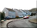
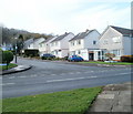
Greave Close, Wenvoe
Houses on the south side of the close, near the northern edge of Wenvoe.
Image: © Jaggery
Taken: 19 Nov 2010
0.15 miles
9
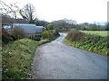
Lane at the northern edge of Wenvoe
An unnamed lane runs between a field http://www.geograph.org.uk/photo/2167662 and houses on Greave Close http://www.geograph.org.uk/photo/2167672 at the northern edge of the village of Wenvoe, Vale of Glamorgan.
Image: © Jaggery
Taken: 19 Nov 2010
0.15 miles
10

Gwenfo / Wenvoe
Cerddwyr yn mynd heibio i Dafarn Wenvoe.
Walkers passing the Wenvoe Arms.
Image: © Alan Richards
Taken: 13 Feb 2011
0.16 miles