IMAGES TAKEN NEAR TO
Station Road East, CARDIFF, CF5 6AH
Introduction
This page details the photographs taken nearby to Station Road East, CF5 6AH by members of the Geograph project.
The Geograph project started in 2005 with the aim of publishing, organising and preserving representative images for every square kilometre of Great Britain, Ireland and the Isle of Man.

There are currently over 7.5m images from over14,400 individuals and you can help contribute to the project by visiting https://www.geograph.org.uk
Image Map
Images are licensed for reuse under creativecommons.org/licenses/by-sa/2.0
Notes
- Clicking on the map will re-center to the selected point.
- The higher the marker number, the further away the image location is from the centre of the postcode.
Image Listing (36 Images Found)
Images are licensed for reuse under creativecommons.org/licenses/by-sa/2.0
Image
Details
Distance
1
Station Road East, Wenvoe
Station Road East heads NE away from the entrance to Ely Rangers AFC ground, http://www.geograph.org.uk/photo/2168802 in the direction of the entrance to Ty Pica Farm.
Image: © Jaggery
Taken: 19 Nov 2010
0.02 miles
2

Ty Pica Farmhouse, Wenvoe
Located on the south side of Station Road East.
Image: © Jaggery
Taken: 19 Nov 2010
0.02 miles
3
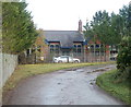
Former railway station building, Wenvoe
Now a private residence, this was formerly the Wenvoe railway station building.
The station closed in 1962.
Image: © Jaggery
Taken: 19 Nov 2010
0.05 miles
4

Former entrance road to Wenvoe railway station
Until the closure of the station in 1962, this was the entrance road from Station Road East into Wenvoe station. The former station building http://www.geograph.org.uk/photo/2168837 is now a private residence. The former station yard http://www.geograph.org.uk/photo/2168850 is now occupied by British Soil (Western) Ltd.
Image: © Jaggery
Taken: 19 Nov 2010
0.05 miles
5
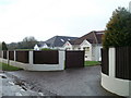
Bungalows, Station Road East, Wenvoe
The bungalows are opposite the former entrance road http://www.geograph.org.uk/photo/2168846 to Wenvoe railway station (closed 1962).
Immediately north east of the bungalows, (behind the camera) Station Road East narrows into an unnamed country lane.http://www.geograph.org.uk/photo/2168969
Image: © Jaggery
Taken: 19 Nov 2010
0.05 miles
6
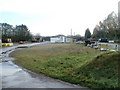
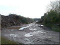
Former railway station yard, Wenvoe
The yard of the former Wenvoe railway station (closed 1962) is now used as horticultural works for organic recycling by British Soil (Western) Ltd.
Image: © Jaggery
Taken: 19 Nov 2010
0.06 miles
7
Country lane crosses former railway bridge, Wenvoe
About 50 metres north of the former Wenvoe railway station, http://www.geograph.org.uk/photo/2168837 a lane crosses a bridge that formerly spanned the railway tracks. The station closed on cessation of passenger services in 1962.
Image: © Jaggery
Taken: 19 Nov 2010
0.09 miles
8
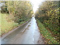
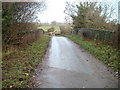
Station Road East narrows to become a country lane
North east of the turning http://www.geograph.org.uk/photo/2168846 into the former Wenvoe station, and bungalows http://www.geograph.org.uk/photo/2168963 on the opposite side of the road, Station Road East becomes a narrow, unnamed country lane.
Image: © Jaggery
Taken: 19 Nov 2010
0.09 miles
9

Recreation ground, Station Road East, Wenvoe
The ground, on the south side of the road, contains several football pitches and an enclosure with two tennis courts side by side.
Image: © Jaggery
Taken: 19 Nov 2010
0.11 miles
10
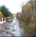
Muddy track on east side of former Wenvoe railway station yard
The track runs south from a country lane (the continuation of Station Road East from Wenvoe) along the eastern edge of the former station yard. http://www.geograph.org.uk/photo/2168850
Image: © Jaggery
Taken: 19 Nov 2010
0.12 miles