IMAGES TAKEN NEAR TO
Heol Trelai, CARDIFF, CF5 5PH
Introduction
This page details the photographs taken nearby to Heol Trelai, CF5 5PH by members of the Geograph project.
The Geograph project started in 2005 with the aim of publishing, organising and preserving representative images for every square kilometre of Great Britain, Ireland and the Isle of Man.

There are currently over 7.5m images from over14,400 individuals and you can help contribute to the project by visiting https://www.geograph.org.uk
Image Map
Images are licensed for reuse under creativecommons.org/licenses/by-sa/2.0
Notes
- Clicking on the map will re-center to the selected point.
- The higher the marker number, the further away the image location is from the centre of the postcode.
Image Listing (13 Images Found)
Images are licensed for reuse under creativecommons.org/licenses/by-sa/2.0
Image
Details
Distance
1
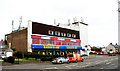
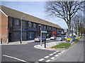
Cowbridge Road West, Ely
This building was originally a cinema between the 1930's and into the 60's. It has subsequently had a variety of uses including offices, a posh car show room: it now houses a video store and a children's day nursery (I trust that the two are not in anyway connected)
Image: © Tony Hodge
Taken: 27 Nov 2006
0.04 miles
2
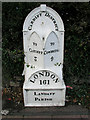
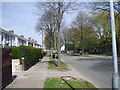
Mile marker on Cowbridge Road West (A48)
I have found 7 of these old cast iron mile markers between Bridgend and the centre of Cardiff. This one is near Ely Police Station. All have been uploaded. Does anyone know their history?
Image: © Tony Hodge
Taken: 27 Nov 2006
0.04 miles
3
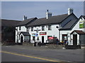
The Highfields Inn, Caerau, Cardiff
On the corner of Caerau Rd and Heol Pantyderi
Image: © John Lord
Taken: 22 Apr 2010
0.12 miles
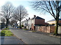
8
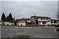
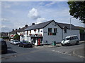
The Caerau Pub Ely - near Heol Trelai Feb 2010
The Caerau Pub in Ely, just off Heol Trelai and previously known as the Anthonys
Image: © Eddie Reed
Taken: 6 Feb 2010
0.23 miles
9
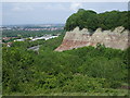
View from the Iron Age fort, Caerau, Cardiff
To the left of the cliff can be seen part of the A4232 link road from the M4 to Cardiff Bay.
Image: © John Lord
Taken: 9 Jun 2010
0.24 miles
10
Caerau Lane, Cardiff
The view to the SW from near the NE end of Caerau Lane.
Image: © Jaggery
Taken: 19 Nov 2010
0.24 miles