IMAGES TAKEN NEAR TO
Caerau Lane, CARDIFF, CF5 5HS
Introduction
This page details the photographs taken nearby to Caerau Lane, CF5 5HS by members of the Geograph project.
The Geograph project started in 2005 with the aim of publishing, organising and preserving representative images for every square kilometre of Great Britain, Ireland and the Isle of Man.

There are currently over 7.5m images from over14,400 individuals and you can help contribute to the project by visiting https://www.geograph.org.uk
Image Map
Images are licensed for reuse under creativecommons.org/licenses/by-sa/2.0
Notes
- Clicking on the map will re-center to the selected point.
- The higher the marker number, the further away the image location is from the centre of the postcode.
Image Listing (17 Images Found)
Images are licensed for reuse under creativecommons.org/licenses/by-sa/2.0
Image
Details
Distance
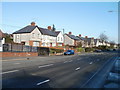
1
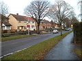
Caerau Lane houses, Cardiff
Houses located between Heol Trelai and Caerau Infants School (ahead).
Image: © Jaggery
Taken: 19 Nov 2010
0.01 miles
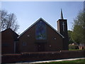
2
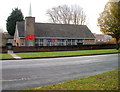
Immanuel Church, Caerau, Cardiff
The church is located on the south side of Heol Trelai. Established in April 1999, the church became part of the Evangelical Presbyterian Church in England and Wales in December 2000.
Image: © Jaggery
Taken: 19 Nov 2010
0.07 miles
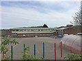
3
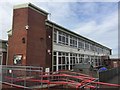
Ysgol Pencaerau
Formerly Cwrt-yr-Ala Junior School.
Image: © Alan Hughes
Taken: 3 May 2018
0.09 miles
4
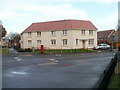
New housing, Cwrt-yr-Ala Road, Cardiff
Recently built housing on the corner of Cwrt-yr-Ala Road and Caerau Lane, close to the junction with Heol Trelai.
Image: © Jaggery
Taken: 19 Nov 2010
0.10 miles
5
Immanuel Evangelical Presbyterian Church, Heol Trelai, Cardiff
Image: © John Lord
Taken: 22 Apr 2010
0.10 miles
6
Pencaerau school
From rmerly Cwrt-yr-Ala Junior School.
Image: © Alan Hughes
Taken: 3 May 2018
0.10 miles
7
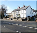
Three houses, Cowbridge Road West, Cardiff
The houses are located on the north side of the road, between Dusty Forge http://www.geograph.org.uk/photo/2167514 beyond the right edge of the photo, and Parker Road.
Image: © Jaggery
Taken: 19 Nov 2010
0.13 miles
8
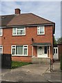
74 Cyntwell Crescent
A typical well-built council house in South Ely from the early 1950s.
Image: © Alan Hughes
Taken: 3 May 2018
0.14 miles
9
Cardiff : Cowbridge Road West houses east of Dusty Forge
Houses on the north side of Cowbridge Road West (A48). The Dusty Forge http://www.geograph.org.uk/photo/2167514 is just beyond the left edge of the view.
Image: © Jaggery
Taken: 19 Nov 2010
0.18 miles
10
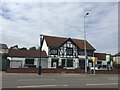
Dusty Forge
Formerly a local pub, the Dusty Forge is now a community centre serving Ely.
Image: © Alan Hughes
Taken: 3 May 2018
0.18 miles