IMAGES TAKEN NEAR TO
Lower Acre, CARDIFF, CF5 5HF
Introduction
This page details the photographs taken nearby to Lower Acre, CF5 5HF by members of the Geograph project.
The Geograph project started in 2005 with the aim of publishing, organising and preserving representative images for every square kilometre of Great Britain, Ireland and the Isle of Man.

There are currently over 7.5m images from over14,400 individuals and you can help contribute to the project by visiting https://www.geograph.org.uk
Image Map
Images are licensed for reuse under creativecommons.org/licenses/by-sa/2.0
Notes
- Clicking on the map will re-center to the selected point.
- The higher the marker number, the further away the image location is from the centre of the postcode.
Image Listing (20 Images Found)
Images are licensed for reuse under creativecommons.org/licenses/by-sa/2.0
Image
Details
Distance
1
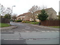
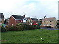
Farmhouse Way, Cardiff
Houses viewed across Caerau Lane.
Image: © Jaggery
Taken: 19 Nov 2010
0.02 miles
2
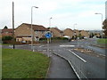
Cardiff : Caerau Lane houses north of Emerson Drive
Turn left at the roundabout for Emerson Drive, http://www.geograph.org.uk/photo/2177524 leading to Worrells Place, Thorne Way and Murrel Close.
Image: © Jaggery
Taken: 19 Nov 2010
0.04 miles
3
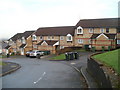
Clos y Rhiw, Caerau, Cardiff
A cul-de-sac of modern housing on the east side of Caerau Lane.
Image: © Jaggery
Taken: 19 Nov 2010
0.07 miles
4
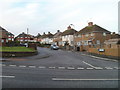
Lon Owain, Caerau, Cardiff
Houses on the north side of Lon Owain, viewed across Caerau Lane.
Image: © Jaggery
Taken: 19 Nov 2010
0.08 miles
5
Emerson Drive, Cardiff
Houses near the western end of Emerson Drive, viewed from the corner of Caerau Lane.
Image: © Jaggery
Taken: 19 Nov 2010
0.10 miles
6
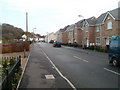
Modern housing, Heol Yr Odyn, Caerau, Cardiff
Viewed from the corner of Caerau Lane.
Image: © Jaggery
Taken: 19 Nov 2010
0.13 miles
7
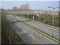
A4232, Caerau.
Looking west along the A4232 from Caerau Lane bridge. The pedestrian footbridge in the photo would appear to connect The Mary Immaculate High School with Caerau. I am not sure if this bridge is still in use ?
Image: © Peter Wasp
Taken: 31 Mar 2007
0.14 miles
8
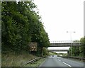
Footbridge and road bridge over A4232 east of Culverhouse Cross
Image: © David Smith
Taken: 19 Sep 2022
0.15 miles
9
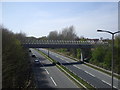
The A4232, Cardiff
Looking west from the Caerau Lane bridge.
Image: © John Lord
Taken: 22 Apr 2010
0.15 miles
10
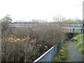
Enclosed footbridge, A4232, Cardiff
This is the northern side of a tubelike enclosed footbridge across the A4232 http://www.geograph.org.uk/photo/1819391 at the southern edge of Cardiff. The southern end of the footbridge is at the edge of a field on the north side of Mary Immaculate High School. http://www.geograph.org.uk/photo/2177406
Image: © Jaggery
Taken: 19 Nov 2010
0.16 miles