IMAGES TAKEN NEAR TO
Old School Road, CARDIFF, CF5 5DP
Introduction
This page details the photographs taken nearby to Old School Road, CF5 5DP by members of the Geograph project.
The Geograph project started in 2005 with the aim of publishing, organising and preserving representative images for every square kilometre of Great Britain, Ireland and the Isle of Man.

There are currently over 7.5m images from over14,400 individuals and you can help contribute to the project by visiting https://www.geograph.org.uk
Image Map
Images are licensed for reuse under creativecommons.org/licenses/by-sa/2.0
Notes
- Clicking on the map will re-center to the selected point.
- The higher the marker number, the further away the image location is from the centre of the postcode.
Image Listing (8 Images Found)
Images are licensed for reuse under creativecommons.org/licenses/by-sa/2.0
Image
Details
Distance

2
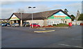
Farmfoods, Ely, Cardiff
Located on the corner of Vincent Road and Cowbridge Road West, opposite Aldi. Farmfoods, who specialise in frozen foods, originated in Aberdeen in 1955. They now have about 300 shops nationwide.
At the right edge of the photo is the bell tower of St David's Church.
Image: © Jaggery
Taken: 19 Nov 2010
0.20 miles
3
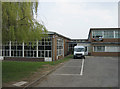
Glyn Derw High School, Ely.
Main entrance into Glyn Derw High School, as seen from Penally Road entrance gate on a Saturday morning
Image: © Peter Wasp
Taken: 31 Mar 2007
0.21 miles
4

Silver Jubilee Cottages, Ely, Cardiff
Located on Cowbridge Road West, opposite the fire station. http://www.geograph.org.uk/photo/289178
Image: © Jaggery
Taken: 19 Nov 2010
0.22 miles
5
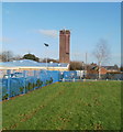
Mobile phone transmitters on Ely Fire Station training tower
The transmitters are about 20 metres (65 feet) above ground level at the top of the fire station http://www.geograph.org.uk/photo/289178 training tower.
Image: © Jaggery
Taken: 19 Nov 2010
0.22 miles
6
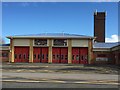
Fire Station
Ely Fire Station on the A48.
Image: © Alan Hughes
Taken: 4 Apr 2016
0.24 miles
7

Ordnance Survey Cut Mark
This OS cut mark can be found on the wall SE side of Cowbridge Road West. It marks a point 14.661m above mean sea level.
Image: © Adrian Dust
Taken: 23 Sep 2021
0.24 miles
8

Construction Site
Early stages of construction of school buildings at Heol Trelai, Ely, Cardiff.
Image: © Alan Hughes
Taken: 15 Nov 2017
0.25 miles