IMAGES TAKEN NEAR TO
Chichester Way, CARDIFF, CF5 5BB
Introduction
This page details the photographs taken nearby to Chichester Way, CF5 5BB by members of the Geograph project.
The Geograph project started in 2005 with the aim of publishing, organising and preserving representative images for every square kilometre of Great Britain, Ireland and the Isle of Man.

There are currently over 7.5m images from over14,400 individuals and you can help contribute to the project by visiting https://www.geograph.org.uk
Image Map
Images are licensed for reuse under creativecommons.org/licenses/by-sa/2.0
Notes
- Clicking on the map will re-center to the selected point.
- The higher the marker number, the further away the image location is from the centre of the postcode.
Image Listing (36 Images Found)
Images are licensed for reuse under creativecommons.org/licenses/by-sa/2.0
Image
Details
Distance
1
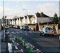
Clarke Street, Ely, Cardiff
Houses on the NW side of the street, viewed from alongside Millbank Primary School. http://www.geograph.org.uk/photo/2166954
The green cones are intended to reinforce the white KEEP CLEAR message on the road surface.
Image: © Jaggery
Taken: 19 Nov 2010
0.02 miles
2
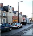
Joseph's Italian Hair Fashions, Cardiff
Located at 14 Riverside Terrace, near the junction with Cowbridge Road West.
Image: © Jaggery
Taken: 19 Nov 2010
0.06 miles
3
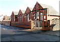
Millbank Primary School, Cardiff
The school is on Clarke Street, Ely. It was formerly named Ely Infants School.
Image: © Jaggery
Taken: 19 Nov 2010
0.06 miles
4
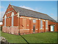
St David's Church Room, Ely
Located on the north side of Clarke Street, opposite Millbank Primary School. http://www.geograph.org.uk/photo/2166954
An inscription on the side of the building shows 1897. The St David's Church website states that the building was sold in the 1980s. There was no indication at the site as to its current use.
Image: © Jaggery
Taken: 19 Nov 2010
0.06 miles
5
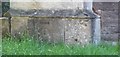
Ordnance Survey Cut Mark
This OS cut mark can be found on the Ely Methodist Church. It marks a point 11.192m above mean sea level.
Image: © Adrian Dust
Taken: 21 Oct 2018
0.06 miles
6
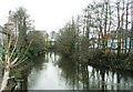
River Ely, Cardiff
Taken from Cowbridge Road river bridge
Image: © Tony Hodge
Taken: 2 Dec 2004
0.07 miles
7
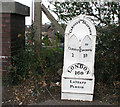
Mile Marker on Cowbridge Road West
I have found 7 of these old cast iron mile markers between Bridgend and the centre of Cardiff. This one is near Ely Roundabout at the railway bridge. All have been uploaded. Does anyone know their history?
Image: © Tony Hodge
Taken: 2 Dec 2006
0.07 miles
8
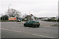
Ely Bridge Roundabout
At the junction of Cowbridge Road and Western Ave
Image: © Tony Hodge
Taken: 2 Dec 2004
0.07 miles
9
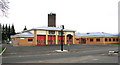
Ely Fire Station, Cowbridge Road West, Cardiff
Image: © Tony Hodge
Taken: 2 Dec 2004
0.07 miles
10
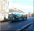
Cardiff bendy bus
The bus is on Cowbridge Road West (A48), heading towards the city centre from Ely. On the back of the bus, a notice states
long bendy bus (18 metres, about 60 feet)
cyclists take care when passing.
http://www.geograph.org.uk/photo/2166888 to the inside of a bendy bus.
Image: © Jaggery
Taken: 19 Nov 2010
0.07 miles