IMAGES TAKEN NEAR TO
Penmaen Walk, CARDIFF, CF5 4TQ
Introduction
This page details the photographs taken nearby to Penmaen Walk, CF5 4TQ by members of the Geograph project.
The Geograph project started in 2005 with the aim of publishing, organising and preserving representative images for every square kilometre of Great Britain, Ireland and the Isle of Man.

There are currently over 7.5m images from over14,400 individuals and you can help contribute to the project by visiting https://www.geograph.org.uk
Image Map
Images are licensed for reuse under creativecommons.org/licenses/by-sa/2.0
Notes
- Clicking on the map will re-center to the selected point.
- The higher the marker number, the further away the image location is from the centre of the postcode.
Image Listing (10 Images Found)
Images are licensed for reuse under creativecommons.org/licenses/by-sa/2.0
Image
Details
Distance
2
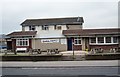
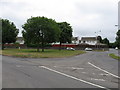
The Cavalier Pub in Michaeston Ely Cardiff
This Pub used to have a nice graphic on its main sign outside which now seems to have disappeared. Anyway the name of the Pub derives from the Battle of St Fagans which took place nearby in 1648 between the Roundheads led by Colonel Thomas Horton and the Cavaliers under the command of Colonel John Poyer, who was Governor of Pembroke Castle at that time.
Colonel Thomas Horton with a detachment of just under 3,000 well-disciplined troops from the New Model Army, was sent by Sir Thomas Fairfax to secure south Wales for Parliament and to crush the rebellion. He had one and a half regiments of Horse (cavalry), most of Colonel Okey's regiment of Dragoons and most of a regiment of Foot (infantry). Horton at first advanced westwards through Wales towards Carmarthen, but then had to march hastily to Brecon to forestall an uprising there. From Brecon, he then marched south to Cardiff, occupying the city before the Royalists could do so. His force took up quarters in and around St. Fagans, west of the city.
Another army under Oliver Cromwell himself was also marching towards Wales. Laugharne was anxious to defeat Horton before Cromwell could reinforce Horton's detachment. After a brief skirmish on 4 May, he launched an attack on 8 May. Laugharne's army consisted of about 7,500 infantry but only 500 cavalry.
Image: © Eddie Reed
Taken: 6 Feb 2010
0.18 miles
3
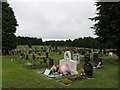
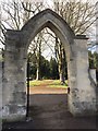
Western Cemetery
View of Western Cemetery, Ely, from the north entrance.
Image: © Alan Hughes
Taken: 19 Feb 2016
0.22 miles
4
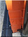
Ordnance Survey Cut Mark
This OS damaged cut mark can be found on No86 Green Farm Road. It marks a point 59.473m above mean sea level.
Image: © Adrian Dust
Taken: 21 Oct 2018
0.22 miles
5
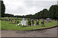
Western Cemetery
South entrance to Western Cemetery, Ely, Cardiff.
Image: © Alan Hughes
Taken: 4 Apr 2016
0.23 miles
7
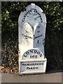
Cast Iron Milestone
4 miles from Cardiff, 8 miles from Cowbridge - and, yes, 162 miles from London, this milestone stands outside Western Cemetery on the A48 in Ely, Cardiff.
Image: © Alan Hughes
Taken: 4 Apr 2016
0.23 miles
8
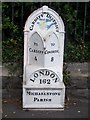
Old Milepost by the A48, Cowbridge Road West, Ely parish
Glamorgan Gothic by the A48, in parish of Ely (City of Cardiff District), Cowbridge Road West; 50m west of entrance to the Western Cemetery.
Inscription reads:-
: TO / CARDIFF / 4 : : CARDIFF DISTRICT : : TO / COWBRIDGE / 8 :
: LONDON / 162 / MICHAELSTONE / PARISH :
Grade II listed by Cadw.
Reference Number: 14083 https://cadwpublic-api.azurewebsites.net/reports/listedbuilding/FullReport?lang=&id=14083
Surveyed
Milestone Society National ID: GLA_162CFCB04
Image: © Milestone Society
Taken: Unknown
0.23 miles
9

Ordnance Survey Cut Mark
This OS cut mark can be found on No491 Cowbridge Road West. It marks a point 58.577m above mean sea level.
Image: © Adrian Dust
Taken: 23 Sep 2021
0.25 miles
10

Ordnance Survey Cut Mark
This OS cut mark can be found on the SW angle of the cemetery wall on Cowbridge Road West. It marks a point 65.556m above mean sea level.
Image: © Adrian Dust
Taken: 23 Sep 2021
0.25 miles