IMAGES TAKEN NEAR TO
Lon Werdd Close, CARDIFF, CF5 4SL
Introduction
This page details the photographs taken nearby to Lon Werdd Close, CF5 4SL by members of the Geograph project.
The Geograph project started in 2005 with the aim of publishing, organising and preserving representative images for every square kilometre of Great Britain, Ireland and the Isle of Man.

There are currently over 7.5m images from over14,400 individuals and you can help contribute to the project by visiting https://www.geograph.org.uk
Image Map
Images are licensed for reuse under creativecommons.org/licenses/by-sa/2.0
Notes
- Clicking on the map will re-center to the selected point.
- The higher the marker number, the further away the image location is from the centre of the postcode.
Image Listing (7 Images Found)
Images are licensed for reuse under creativecommons.org/licenses/by-sa/2.0
Image
Details
Distance
1
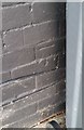
Ordnance Survey Cut Mark
This OS cut mark can be found on No43 Mostyn Road. It marks a point 62.560m above mean sea level.
Image: © Adrian Dust
Taken: 21 Oct 2018
0.11 miles
2
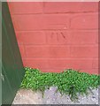
Ordnance Survey Cut Mark
This OS cut mark can be found on No398 Grand Avenue. It marks a point 58.369m above mean sea level.
Image: © Adrian Dust
Taken: 21 Oct 2018
0.17 miles
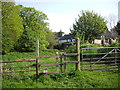
4
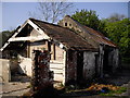
Derelict outbuildings, Michaelston-super-Ely
Image: © John Lord
Taken: 17 Apr 2011
0.23 miles
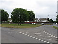
6
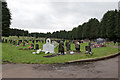
Western Cemetery
View of Western Cemetery, Ely, from the north entrance.
Image: © Alan Hughes
Taken: 19 Feb 2016
0.24 miles
7
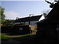
Old farmhouse awaiting redevelopment, Michaelston-super-Ely
Image: © John Lord
Taken: 17 Apr 2011
0.25 miles