IMAGES TAKEN NEAR TO
Deere Road, CARDIFF, CF5 4NJ

Introduction

This page details the photographs taken nearby to Deere Road, CF5 4NJ by members of the Geograph project.

The Geograph project started in 2005 with the aim of publishing, organising and preserving representative images for every square kilometre of Great Britain, Ireland and the Isle of Man.

There are currently over 7.5m images from over14,400 individuals and you can help contribute to the project by visiting https://www.geograph.org.uk

Image Map


Images are licensed for reuse under creativecommons.org/licenses/by-sa/2.0
Notes
  • Clicking on the map will re-center to the selected point.
  • The higher the marker number, the further away the image location is from the centre of the postcode.

Image Listing (19 Images Found)

Images are licensed for reuse under creativecommons.org/licenses/by-sa/2.0
Image
Details
Distance
1
Cardiff Trolleybus route 10B at Ely
A view taken to complement Image complete with the same 'phone box! The route 10 at Ely was the last extension to the Cardiff Trolleybus system before a change of policy led to its run down in favour of diesel buses and eventual closure in 1970. If I remember correctly the 10A and 10B both ran to Ely but took opposite directions on a loop around the housing estate. I think this picture was taken only months before closure, but I'm open to correction. The original slide was very underexposed and it is only thanks to modern digital processing that it has been possible to recover this image.
Image: © David Stowell Taken: Unknown
0.10 miles
2
British Trolleybuses - Cardiff
The busiest trolleybus route in Cardiff served the large Ely housing estate. The services were provided in the form of a loop running out via Cowbridge Road and returning via Grand Avenue, or vice versa. The main service operated along Macdonald Road, which can be seen diverging to the left from Grand Avenue at this point. The trolleybus in the picture has come from Green Farm Road. This was an extra loop which was served in one direction only by about one in three of the journeys operating clockwise. This scene appears to have changed very little in 40 years, although there are now some trees in the reservation of Grand Avenue. For a slide show of British Trolleybuses in the late 60s http://www.geograph.org.uk/search.php?i=1773236&displayclass=slide
Image: © Alan Murray-Rust Taken: 20 Mar 1966
0.10 miles
3
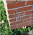
Ordnance Survey Cut Mark
This OS cut mark can be found on No290 Grand Avenue. It marks a point 55.443m above mean sea level.
Image: © Adrian Dust Taken: 21 Oct 2018
0.14 miles
4
Dusty Forge, Cardiff
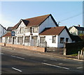
Located at 460 Cowbridge Road West. Formerly a pub, Dusty Forge is now a youth centre providing a range of services for young people.
Image: © Jaggery Taken: 19 Nov 2010
0.14 miles
5
Ordnance Survey Cut Mark
This OS cut mark can be found on No156 Snowden Road. It marks a point 57.446m above mean sea level.
Image: © Adrian Dust Taken: 21 Oct 2018
0.14 miles
6
Ordnance Survey Cut Mark
This OS cut mark can be found on No63 MacDonald Road. It marks a point 58.244m above mean sea level.
Image: © Adrian Dust Taken: 21 Oct 2018
0.15 miles
7
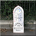
Mile marker on A48 outside Ely cemetery
I have found 7 of these old cast iron mile markers between Bridgend and the centre of Cardiff. All have been uploaded. Does anyone know their history?
Image: © Tony Hodge Taken: 27 Nov 2006
0.16 miles
8
Western Cemetery, Ely, Cardiff
The main gateways
Image: © Tony Hodge Taken: 9 Nov 2006
0.16 miles
9
Western Cemetery, Ely, Cardiff
In the Muslim sector of the graveyard
Image: © Tony Hodge Taken: 9 Nov 2006
0.16 miles
10
Western cemetery, Ely
Image: © caroline n Taken: 23 Oct 2006
0.16 miles