IMAGES TAKEN NEAR TO
Wheatley Road, CARDIFF, CF5 4LW
Introduction
This page details the photographs taken nearby to Wheatley Road, CF5 4LW by members of the Geograph project.
The Geograph project started in 2005 with the aim of publishing, organising and preserving representative images for every square kilometre of Great Britain, Ireland and the Isle of Man.

There are currently over 7.5m images from over14,400 individuals and you can help contribute to the project by visiting https://www.geograph.org.uk
Image Map
Images are licensed for reuse under creativecommons.org/licenses/by-sa/2.0
Notes
- Clicking on the map will re-center to the selected point.
- The higher the marker number, the further away the image location is from the centre of the postcode.
Image Listing (21 Images Found)
Images are licensed for reuse under creativecommons.org/licenses/by-sa/2.0
Image
Details
Distance
1
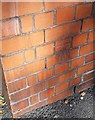
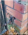
Ordnance Survey Cut Mark
This OS cut mark can be found on the school wall, Grand Avenue. It marks a point 44.757m above mean sea level.
Image: © Adrian Dust
Taken: 21 Oct 2018
0.10 miles
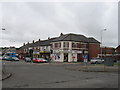
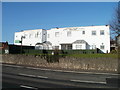
3
Crown House, Cowbridge Road West, Cardiff
A large building at 364-372 Cowbridge Road West, with several occupants, including:
Blockbuster Video
Phoenix Fitness & Community Centre
Pili Pila Day Nursery
Feng Huang Kung Fu Association.
Image: © Jaggery
Taken: 19 Nov 2010
0.11 miles
4
Hillsnook Road, Cardiff
Viewed across Cowbridge Road West. Hillsnook Road leads to two cul-de-sacs, Llanwern Road and Nottage Road. The fence on the left is at the perimeter of Crown House. http://www.geograph.org.uk/photo/2167427
Image: © Jaggery
Taken: 19 Nov 2010
0.11 miles
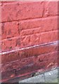
5
Ordnance Survey Cut Mark
This OS cut mark can be found on No8 Wilson Road. It marks a point 35.918m above mean sea level.
Image: © Adrian Dust
Taken: 21 Oct 2018
0.12 miles
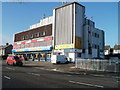
6
Cardiff West End Social Club
Located at 348 Cowbridge Road West.
Image: © Jaggery
Taken: 19 Nov 2010
0.14 miles
7
Ordnance Survey Cut Mark
This OS cut mark can be found on No15 Crossways Road. It marks a point 30.949m above mean sea level.
Image: © Adrian Dust
Taken: 21 Oct 2018
0.15 miles
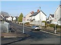
8
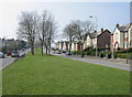
Grand Avenue, Ely.
Looking along Grand Avenue in a westerly direction, at its junction with Wilson Road.
Image: © Peter Wasp
Taken: 31 Mar 2007
0.16 miles
9
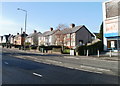
Cardiff : Cowbridge Road West houses between Crown House and Wilson Road
Houses on the north side of Cowbridge Road West. At the right edge of the view is Blockbuster Video, located in Crown House. http://www.geograph.org.uk/photo/2167427
Image: © Jaggery
Taken: 19 Nov 2010
0.17 miles
10
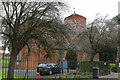
Church of the Resurrection
Church of the Resurrection, Grand Avenue, Ely.
Image: © Alan Hughes
Taken: 19 Feb 2016
0.18 miles