IMAGES TAKEN NEAR TO
Wheatley Road, CARDIFF, CF5 4LT
Introduction
This page details the photographs taken nearby to Wheatley Road, CF5 4LT by members of the Geograph project.
The Geograph project started in 2005 with the aim of publishing, organising and preserving representative images for every square kilometre of Great Britain, Ireland and the Isle of Man.

There are currently over 7.5m images from over14,400 individuals and you can help contribute to the project by visiting https://www.geograph.org.uk
Image Map
Images are licensed for reuse under creativecommons.org/licenses/by-sa/2.0
Notes
- Clicking on the map will re-center to the selected point.
- The higher the marker number, the further away the image location is from the centre of the postcode.
Image Listing (20 Images Found)
Images are licensed for reuse under creativecommons.org/licenses/by-sa/2.0
Image
Details
Distance
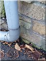
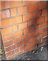
1
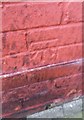
Ordnance Survey Cut Mark
This OS cut mark can be found on No15 Crossways Road. It marks a point 30.949m above mean sea level.
Image: © Adrian Dust
Taken: 21 Oct 2018
0.07 miles
2
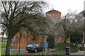
Church of the Resurrection
Church of the Resurrection, Grand Avenue, Ely.
Image: © Alan Hughes
Taken: 19 Feb 2016
0.10 miles
4
Ordnance Survey Cut Mark
This OS cut mark can be found on No124 Grand Avenue. It marks a point 38.435m above mean sea level.
Image: © Adrian Dust
Taken: 21 Oct 2018
0.12 miles
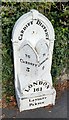
6
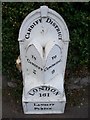
Old Milepost by the A48, Cowbridge Road West, Ely parish
Glamorgan Gothic milepost by the A48, in parish of Ely (City of Cardiff District), Cowbridge Road West, against wall of No 322 at junction with Crossways Road.
Inscription reads:-
: TO / CARDIFF / 3 : : CARDIFF DISTRICT : : TO / COWBRIDG / 9 :
: LONDON / 161 / LANDAFF PARISH :
Grade II listed by Cadw.
Reference Number: 14084 https://cadwpublic-api.azurewebsites.net/reports/listedbuilding/FullReport?lang=&id=14084
Surveyed
Milestone Society National ID: GLA_161CFCB03
Image: © Milestone Society
Taken: Unknown
0.15 miles
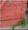
7
Ordnance Survey Cut Mark
This OS cut mark can be found on the north angle of Crossways Cottages. It marks a point 23.186m above mean sea level.
Image: © Adrian Dust
Taken: 21 Oct 2018
0.16 miles
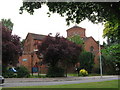
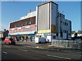
8
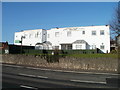
Cardiff West End Social Club
Located at 348 Cowbridge Road West.
Image: © Jaggery
Taken: 19 Nov 2010
0.17 miles
9
Ordnance Survey Cut Mark
This OS cut mark can be found on the school wall, Grand Avenue. It marks a point 44.757m above mean sea level.
Image: © Adrian Dust
Taken: 21 Oct 2018
0.17 miles
10
Crown House, Cowbridge Road West, Cardiff
A large building at 364-372 Cowbridge Road West, with several occupants, including:
Blockbuster Video
Phoenix Fitness & Community Centre
Pili Pila Day Nursery
Feng Huang Kung Fu Association.
Image: © Jaggery
Taken: 19 Nov 2010
0.18 miles