1
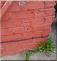
Ordnance Survey Cut Mark
This OS cut mark can be found on No15 Crossways Road. It marks a point 30.949m above mean sea level.
Image: © Adrian Dust
Taken: 21 Oct 2018
0.01 miles
2
Milepost - Cardiff 3
Image: © Adrian Dust
Taken: 21 Oct 2018
0.09 miles
3
Old Milepost by the A48, Cowbridge Road West, Ely parish
Glamorgan Gothic milepost by the A48, in parish of Ely (City of Cardiff District), Cowbridge Road West, against wall of No 322 at junction with Crossways Road.
Inscription reads:-
: TO / CARDIFF / 3 : : CARDIFF DISTRICT : : TO / COWBRIDG / 9 :
: LONDON / 161 / LANDAFF PARISH :
Grade II listed by Cadw.
Reference Number: 14084 https://cadwpublic-api.azurewebsites.net/reports/listedbuilding/FullReport?lang=&id=14084
Surveyed
Milestone Society National ID: GLA_161CFCB03
Image: © Milestone Society
Taken: Unknown
0.10 miles
4
Ordnance Survey Cut Mark
This OS cut mark can be found on the north angle of Crossways Cottages. It marks a point 23.186m above mean sea level.
Image: © Adrian Dust
Taken: 21 Oct 2018
0.11 miles
5
Church of the Resurrection
Church of the Resurrection, Grand Avenue, Ely.
Image: © Alan Hughes
Taken: 19 Feb 2016
0.15 miles
6
Cardiff West End Social Club
Located at 348 Cowbridge Road West.
Image: © Jaggery
Taken: 19 Nov 2010
0.15 miles
7
Church in Ely, Cardiff
Image: © Gareth James
Taken: 7 Jul 2010
0.15 miles
8
Ordnance Survey Cut Mark
This OS cut mark can be found on No124 Grand Avenue. It marks a point 38.435m above mean sea level.
Image: © Adrian Dust
Taken: 21 Oct 2018
0.15 miles
9
Ely, Western Leisure Centre
On Caerau Lane: https://www.cardiff.gov.uk/ENG/resident/Leisure-parks-and-culture/Leisure-centres-and-facilities/Find-a-Leisure-Centre/Leisure-Centres/Pages/Western-Leisure-Centre.aspx
Image: © Mike Faherty
Taken: 12 Jul 2016
0.15 miles
10
Western Leisure Centre, Ely, Cardiff
Located on the east side of Caerau Lane.
Western Leisure Centre opened in 1979. Among its facilities are :
Gymnasium and fitness suite; cardio theatre; dance studio; training/meeting room ; community room, used for a variety of purposes such as creche, martial arts, children's parties. There is an outdoor floodlit multi-use games area for football, basketball and tennis.
The main swimming pool is 25 metres by 12.5 metres, with a teaching pool of 13 metres by 7 metres.
Image: © Jaggery
Taken: 19 Nov 2010
0.16 miles


