IMAGES TAKEN NEAR TO
Pethybridge Road, CARDIFF, CF5 4DT
Introduction
This page details the photographs taken nearby to Pethybridge Road, CF5 4DT by members of the Geograph project.
The Geograph project started in 2005 with the aim of publishing, organising and preserving representative images for every square kilometre of Great Britain, Ireland and the Isle of Man.

There are currently over 7.5m images from over14,400 individuals and you can help contribute to the project by visiting https://www.geograph.org.uk
Image Map
Images are licensed for reuse under creativecommons.org/licenses/by-sa/2.0
Notes
- Clicking on the map will re-center to the selected point.
- The higher the marker number, the further away the image location is from the centre of the postcode.
Image Listing (21 Images Found)
Images are licensed for reuse under creativecommons.org/licenses/by-sa/2.0
Image
Details
Distance
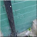
1
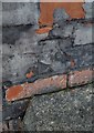
Ordnance Survey Cut Mark
This OS cut mark can be found on No7 Llewellyn Avenue. It marks a point 57.775m above mean sea level.
Image: © Adrian Dust
Taken: 21 Oct 2018
0.07 miles
4
Ordnance Survey Cut Mark
This OS cut mark can be found on No55 Archer Road. It marks a point 45.888m above mean sea level.
Image: © Adrian Dust
Taken: 21 Oct 2018
0.11 miles
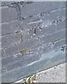
8
Ordnance Survey Cut Mark
This OS cut mark can be found on No61 Llewellyn Avenue. It marks a point 62.585m above mean sea level.
Image: © Adrian Dust
Taken: 21 Oct 2018
0.18 miles
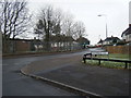
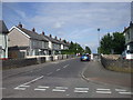
10
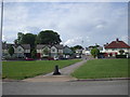
Path across roundabout
Junction of Archer Rd & Wilson Rd, Ely, Cardiff
Image: © John Lord
Taken: 9 Jun 2010
0.22 miles