IMAGES TAKEN NEAR TO
Pengwern Road, CARDIFF, CF5 4BS
Introduction
This page details the photographs taken nearby to Pengwern Road, CF5 4BS by members of the Geograph project.
The Geograph project started in 2005 with the aim of publishing, organising and preserving representative images for every square kilometre of Great Britain, Ireland and the Isle of Man.

There are currently over 7.5m images from over14,400 individuals and you can help contribute to the project by visiting https://www.geograph.org.uk
Image Map
Images are licensed for reuse under creativecommons.org/licenses/by-sa/2.0
Notes
- Clicking on the map will re-center to the selected point.
- The higher the marker number, the further away the image location is from the centre of the postcode.
Image Listing (22 Images Found)
Images are licensed for reuse under creativecommons.org/licenses/by-sa/2.0
Image
Details
Distance
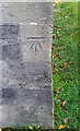
1
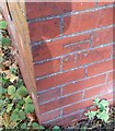
Ordnance Survey Cut Mark
This OS cut mark can be found on No26 Grand Avenue. It marks a point 14.758m above mean sea level.
Image: © Adrian Dust
Taken: 21 Oct 2018
0.06 miles
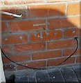
2
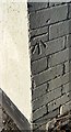
Ordnance Survey Cut Mark
This OS cut mark can be found on No47 Heol Muston. It marks a point 18.099m above mean sea level.
Image: © Adrian Dust
Taken: 21 Oct 2018
0.08 miles
3
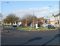
Grand Avenue, Ely, Cardiff
The view along Grand Avenue from the T junction with Cowbridge Road West.
Image: © Jaggery
Taken: 19 Nov 2010
0.10 miles
4
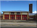
Fire Station
Ely Fire Station on the A48.
Image: © Alan Hughes
Taken: 4 Apr 2016
0.11 miles
5
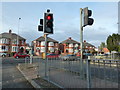
Junction of Vincent Road with Cowbridge Road West, Ely, Cardiff
Image: © Ruth Sharville
Taken: 3 Feb 2011
0.14 miles
6
Ordnance Survey Cut Mark
This OS cut mark can be found on the south angle of St David's Church. It marks a point 13.113m above mean sea level.
Image: © Adrian Dust
Taken: 21 Oct 2018
0.15 miles
7
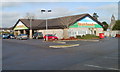
Farmfoods, Ely, Cardiff
Located on the corner of Vincent Road and Cowbridge Road West, opposite Aldi. Farmfoods, who specialise in frozen foods, originated in Aberdeen in 1955. They now have about 300 shops nationwide.
At the right edge of the photo is the bell tower of St David's Church.
Image: © Jaggery
Taken: 19 Nov 2010
0.15 miles
8
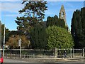
St.David Church
St.David Church, Ely, Cardiff - shrouded in trees.
Image: © Alan Hughes
Taken: 4 Apr 2016
0.16 miles
9
Ordnance Survey Cut Mark
This OS cut mark can be found on No4 Charteris Road. It marks a point 18.251m above mean sea level.
Image: © Adrian Dust
Taken: 21 Oct 2018
0.16 miles
10

Silver Jubilee Cottages, Ely, Cardiff
Located on Cowbridge Road West, opposite the fire station. http://www.geograph.org.uk/photo/289178
Image: © Jaggery
Taken: 19 Nov 2010
0.16 miles