IMAGES TAKEN NEAR TO
Beechley Drive, CARDIFF, CF5 3SN
Introduction
This page details the photographs taken nearby to Beechley Drive, CF5 3SN by members of the Geograph project.
The Geograph project started in 2005 with the aim of publishing, organising and preserving representative images for every square kilometre of Great Britain, Ireland and the Isle of Man.

There are currently over 7.5m images from over14,400 individuals and you can help contribute to the project by visiting https://www.geograph.org.uk
Image Map
Images are licensed for reuse under creativecommons.org/licenses/by-sa/2.0
Notes
- Clicking on the map will re-center to the selected point.
- The higher the marker number, the further away the image location is from the centre of the postcode.
Image Listing (5 Images Found)
Images are licensed for reuse under creativecommons.org/licenses/by-sa/2.0
Image
Details
Distance
1
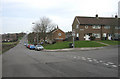
Pentrebane Road, Cardiff.
Looking east along Pentrebane Road at the junction with Beechley Road.
Image: © Peter Wasp
Taken: 11 Mar 2007
0.15 miles
2
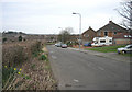
Pentrebane Road, Cardiff.
View looking East along Pentrebane Road
Image: © Peter Wasp
Taken: 11 Mar 2007
0.15 miles
3
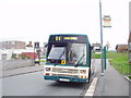
Pentrebane Bus Stop and Pub
Bus stop opposite the Jug & Bottle pub. A Leyland Lynx calls on the last day in service in Cardiff for these buses.
Image: © David Roberts
Taken: 19 Oct 2007
0.15 miles
4
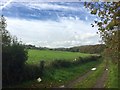
Waterhall Plantation
Track leading from Pentrebane Road towards the Waterhall Plantation.
Image: © Alan Hughes
Taken: 17 Oct 2018
0.18 miles
5
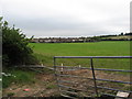
Fields on the edge of Pentrebane, Cardiff
Image: © Gareth James
Taken: 27 Sep 2010
0.23 miles