1
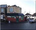
Llandetty Road houses, Cardiff
Houses on the west side of the road, viewed from the St Fagans Road end.
Image: © Jaggery
Taken: 17 Dec 2013
0.07 miles
2
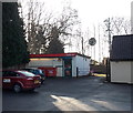
St Fagans Road Post Office, Fairwater, Cardiff
Located at 121 St Fagans Road, on the corner of Llangattock Road.
Image: © Jaggery
Taken: 17 Dec 2013
0.08 miles
3
Norbury Avenue, Fairwater, Cardiff
Norbury Avenue is a 90 metre long cul-de-sac on the west side of Norbury Road.
Image: © Jaggery
Taken: 17 Dec 2013
0.11 miles
4
Ladbrokes, Fairwater, Cardiff
Betting shop set back 25 metres from the south side of St Fagans Road, near the Fairwater pub. http://www.geograph.org.uk/photo/3783648
Image: © Jaggery
Taken: 17 Dec 2013
0.12 miles
5
St David's Lutheran Church, Fairwater, Cardiff
Located between St Fagans Road and Doyle Avenue, the church is part of The Evangelical Lutheran Church of England, a Christian denomination. The evangelical element in the name indicates that the church believes, teaches and preaches the Good News of salvation through faith alone in Jesus Christ. The Lutheran element is in memory of Dr Martin Luther (1483-1546), the Protestant reformer, who lived in what is now Germany. Though this congregation is in Wales, the official name includes
Church of England because it was in London that their synod began in 1896.
Image: © Jaggery
Taken: 17 Dec 2013
0.12 miles
6
Ordnance Survey Cut Mark
This OS damaged and moved cut mark can be found on the wall at the road junction. It marks a point 14.836m above mean sea level.
Image: © Adrian Dust
Taken: 18 Oct 2018
0.13 miles
7
The Fairwater, Cardiff
Pub on the corner of St Fagans Road and Cartwright Lane in the Fairwater area of Cardiff.
Image: © Jaggery
Taken: 17 Dec 2013
0.13 miles
8
Ordnance Survey Cut Mark
This OS cut mark can be found on No79 Bwlch Road. It marks a point 10.970m above mean sea level.
Image: © Adrian Dust
Taken: 18 Oct 2018
0.14 miles
9
Ordnance Survey Flush Bracket (G3712)
This heavily covered OS Flush Bracket can be found on the Fairwater Hotel. It marks a point 14.635m above mean sea level.
Image: © Adrian Dust
Taken: 18 Oct 2018
0.14 miles
10
Ordnance Survey Cut Mark
This OS cut mark can be found on the gatepost of No26 Cartwright Lane. It marks a point 12.695m above mean sea level.
Image: © Adrian Dust
Taken: 18 Oct 2018
0.14 miles


