IMAGES TAKEN NEAR TO
Allan Durst Close, CARDIFF, CF5 2RP
Introduction
This page details the photographs taken nearby to Allan Durst Close, CF5 2RP by members of the Geograph project.
The Geograph project started in 2005 with the aim of publishing, organising and preserving representative images for every square kilometre of Great Britain, Ireland and the Isle of Man.

There are currently over 7.5m images from over14,400 individuals and you can help contribute to the project by visiting https://www.geograph.org.uk
Image Map
Images are licensed for reuse under creativecommons.org/licenses/by-sa/2.0
Notes
- Clicking on the map will re-center to the selected point.
- The higher the marker number, the further away the image location is from the centre of the postcode.
Image Listing (54 Images Found)
Images are licensed for reuse under creativecommons.org/licenses/by-sa/2.0
Image
Details
Distance
1
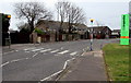
Zebra crossing, Danescourt, Cardiff
Across Danescourt Way near the Cadoc Place junction.
Image: © Jaggery
Taken: 5 Mar 2015
0.05 miles
2
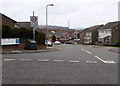
Timothy Rees Close, Danescourt, Cardiff
Viewed across Danescourt Way. The large street name sign lists the many streets (all cul-de-sacs) ahead.
The 20 mph speed limit past a school increases to 30 mph along Timothy Rees Close.
Image: © Jaggery
Taken: 5 Mar 2015
0.06 miles
3
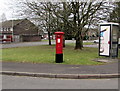
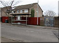
King George V pillar box and grey phonebox, Danescourt, Cardiff
Alongside Cadoc Place, near Danescourt Way.
Image: © Jaggery
Taken: 5 Mar 2015
0.07 miles
4
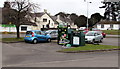
Clothing and shoes donation bins, Danescourt, Cardiff
In the car park between Danescourt Way and the Co-operative Food Store. http://www.geograph.org.uk/photo/4372133
The larger bin is for the Salvation Army.
Image: © Jaggery
Taken: 5 Mar 2015
0.07 miles
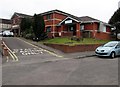
5
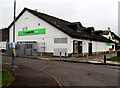
Danescourt Shopping Centre electricity substation, Cardiff
The Western Power Distribution electricity substation is inside the brick compound on the right,
protected by locked grey gates with spiked tops.
The identifier is DANESCOURT SHOPPING CENTRE RADYR S/S 513089.
Image: © Jaggery
Taken: 5 Mar 2015
0.07 miles
7
The Co-operative Food Store, Danescourt, Cardiff
Viewed from Cadoc Place on the south side of Danescourt Way.
Image: © Jaggery
Taken: 5 Mar 2015
0.09 miles
8
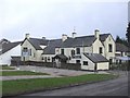
Radyr Court and the Co-operative Food Store, Danescourt, Cardiff
On the south side of Danescourt Way. Radyr Court pub is on the site of the medieval manor house Radyr Court, destroyed by fire in the 19th century. The building seen here on the right used to be a farmhouse.
Image: © Jaggery
Taken: 5 Mar 2015
0.10 miles
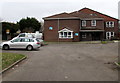
9
Danescourt Surgery and Danescourt Pharmacy, Cardiff
Viewed across Rachel Close. Pharmacy on the right, surgery on the left.
Image: © Jaggery
Taken: 5 Mar 2015
0.10 miles
10
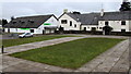
Restway Court, Danescourt Way, Cardiff
Managed by Wales & West Housing, Restway Court is retirement/sheltered housing containing 22 flats built in 1986.
Image: © Jaggery
Taken: 5 Mar 2015
0.10 miles