IMAGES TAKEN NEAR TO
Douglas Close, CARDIFF, CF5 2QT
Introduction
This page details the photographs taken nearby to Douglas Close, CF5 2QT by members of the Geograph project.
The Geograph project started in 2005 with the aim of publishing, organising and preserving representative images for every square kilometre of Great Britain, Ireland and the Isle of Man.

There are currently over 7.5m images from over14,400 individuals and you can help contribute to the project by visiting https://www.geograph.org.uk
Image Map
Images are licensed for reuse under creativecommons.org/licenses/by-sa/2.0
Notes
- Clicking on the map will re-center to the selected point.
- The higher the marker number, the further away the image location is from the centre of the postcode.
Image Listing (53 Images Found)
Images are licensed for reuse under creativecommons.org/licenses/by-sa/2.0
Image
Details
Distance
1
Turn left here for Danescourt railway station, Cardiff
The sign at the edge of Danescourt Way points along Beale Close towards Danescourt, a suburban station on the City Line.
Image: © Jaggery
Taken: 5 Mar 2015
0.08 miles
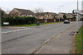
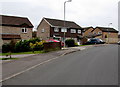
2
Edward Clarke Close, Danescourt, Cardiff
Looking south from Beale Close. Edward Clarke Close leads to Jasper Close.
Image: © Jaggery
Taken: 5 Mar 2015
0.08 miles
3
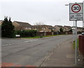
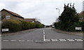
Southern end of the 20 zone along Danescourt Way, Cardiff
The 20mph speed limit near Danescourt Primary School increases to 30mph.
The left turn into Beale Close leads to Danescourt railway station.
Image: © Jaggery
Taken: 5 Mar 2015
0.09 miles
4
Start of the 20 zone along Danescourt Way, Cardiff
The 30mph speed limit reduces to 20mph on the southern approach to Danescourt Primary School.
Image: © Jaggery
Taken: 5 Mar 2015
0.09 miles
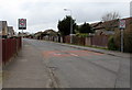
5
SE side of Mathew Walk, Danescourt, Cardiff
Part of a large area of houses built in the 1970s.
Image: © Jaggery
Taken: 5 Mar 2015
0.11 miles
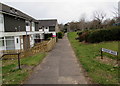
6
Beale Close, Danescourt, Cardiff
Viewed across Danescourt Way. Beale Close leads to several cul-de-sacs and to Danescourt railway station.
Image: © Jaggery
Taken: 5 Mar 2015
0.11 miles
7
Mathew Walk, Danescourt, Cardiff
On the west side of Danescourt Way.
Image: © Jaggery
Taken: 5 Mar 2015
0.12 miles
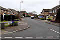
8
Beale Close houses, Danescourt, Cardiff
Looking towards the Edward Clarke Close http://www.geograph.org.uk/photo/4371922 junction, a few metres out of shot ahead.
Image: © Jaggery
Taken: 5 Mar 2015
0.12 miles
9
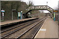
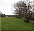
Danescourt railway station footbridge, Cardiff
Danescourt is on the suburban City Line, between the Radyr terminus to the north and Fairwater station to the south. About 120 metres behind the footbridge, a road bridge carries the A4119 Llantrisant Road over the tracks.
Image: © Jaggery
Taken: 5 Mar 2015
0.13 miles
10
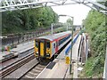
Platform extensions at Danescourt station
Class 153 unit No. 153913 approaches Danescourt station with a Coryton to Radyr service, and is seen passing the under-construction platform extensions at the southern end of the station.
Image: © Gareth James
Taken: 8 Sep 2023
0.13 miles