1
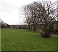
SE side of Mathew Walk, Danescourt, Cardiff
Part of a large area of houses built in the 1970s.
Image: © Jaggery
Taken: 5 Mar 2015
0.07 miles
2
Mathew Walk, Danescourt, Cardiff
On the west side of Danescourt Way.
Image: © Jaggery
Taken: 5 Mar 2015
0.10 miles
3
Turn left here for Danescourt railway station, Cardiff
The sign at the edge of Danescourt Way points along Beale Close towards Danescourt, a suburban station on the City Line.
Image: © Jaggery
Taken: 5 Mar 2015
0.10 miles
4
Southern end of the 20 zone along Danescourt Way, Cardiff
The 20mph speed limit near Danescourt Primary School increases to 30mph.
The left turn into Beale Close leads to Danescourt railway station.
Image: © Jaggery
Taken: 5 Mar 2015
0.11 miles
5
Start of the 20 zone along Danescourt Way, Cardiff
The 30mph speed limit reduces to 20mph on the southern approach to Danescourt Primary School.
Image: © Jaggery
Taken: 5 Mar 2015
0.11 miles
6
Junior Play Area, Mathew Walk, Danescourt, Cardiff
On the corner of Mathew Walk and Danescourt Way, south of Danescourt Primary School.
A notice states that this area is designed for children aged 4-14.
Image: © Jaggery
Taken: 5 Mar 2015
0.11 miles
7
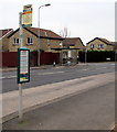
Two bus stops but only one bus shelter, Danescourt Way, Cardiff
The shelter is near the corner of Burne Jones Close.
Image: © Jaggery
Taken: 5 Mar 2015
0.12 miles
8
Edward Clarke Close, Danescourt, Cardiff
Looking south from Beale Close. Edward Clarke Close leads to Jasper Close.
Image: © Jaggery
Taken: 5 Mar 2015
0.13 miles
9
Beale Close, Danescourt, Cardiff
Viewed across Danescourt Way. Beale Close leads to several cul-de-sacs and to Danescourt railway station.
Image: © Jaggery
Taken: 5 Mar 2015
0.13 miles
10
Mathew Walk houses, Danescourt, Cardiff
At the edge of a green near this church. http://www.geograph.org.uk/photo/4379729
Image: © Jaggery
Taken: 5 Mar 2015
0.14 miles


