IMAGES TAKEN NEAR TO
Tangmere Drive, CARDIFF, CF5 2PQ
Introduction
This page details the photographs taken nearby to Tangmere Drive, CF5 2PQ by members of the Geograph project.
The Geograph project started in 2005 with the aim of publishing, organising and preserving representative images for every square kilometre of Great Britain, Ireland and the Isle of Man.

There are currently over 7.5m images from over14,400 individuals and you can help contribute to the project by visiting https://www.geograph.org.uk
Image Map
Images are licensed for reuse under creativecommons.org/licenses/by-sa/2.0
Notes
- Clicking on the map will re-center to the selected point.
- The higher the marker number, the further away the image location is from the centre of the postcode.
Image Listing (50 Images Found)
Images are licensed for reuse under creativecommons.org/licenses/by-sa/2.0
Image
Details
Distance
1
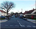
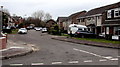
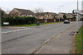
Western end of Keyston Road, Fairwater, Cardiff
Looking east across Waterhall Road.
Image: © Jaggery
Taken: 9 Jan 2014
0.07 miles
2
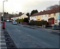
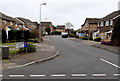
Keyston Road postbox and bus stop, Cardiff
The bus stop and postbox on the left are near the Amethyst Road junction.
Image: © Jaggery
Taken: 9 Jan 2014
0.12 miles
3
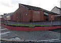
Church hall on the corner of Keyston Road and Amethyst Road, Cardiff
On the north side of The Holy Family Catholic Church. http://www.geograph.org.uk/photo/3810881
Image: © Jaggery
Taken: 9 Jan 2014
0.13 miles
4
Amethyst Road, Cardiff
Looking WSW from Keyston Road.
Image: © Jaggery
Taken: 9 Jan 2014
0.14 miles
5
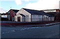
The Holy Family Catholic Church, Fairwater, Cardiff
The church on the corner of Carter Place and Keyston Road is part of the Roman Catholic Archdiocese of Cardiff.
Image: © Jaggery
Taken: 9 Jan 2014
0.14 miles
6
SE side of Mathew Walk, Danescourt, Cardiff
Part of a large area of houses built in the 1970s.
Image: © Jaggery
Taken: 5 Mar 2015
0.16 miles
7
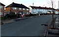
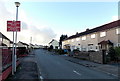
Change of house type in Keyston Road, Cardiff
Looking towards the Carter Place junction, out of shot a few metres beyond the van.
Image: © Jaggery
Taken: 9 Jan 2014
0.17 miles
8
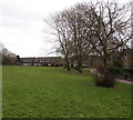
Piper Close, Danescourt, Cardiff
Cul-de-sac viewed from Heol Seddon.
Image: © Jaggery
Taken: 5 Mar 2015
0.18 miles
9
Turn left here for Danescourt railway station, Cardiff
The sign at the edge of Danescourt Way points along Beale Close towards Danescourt, a suburban station on the City Line.
Image: © Jaggery
Taken: 5 Mar 2015
0.19 miles
10
Edward Clarke Close, Danescourt, Cardiff
Looking south from Beale Close. Edward Clarke Close leads to Jasper Close.
Image: © Jaggery
Taken: 5 Mar 2015
0.19 miles