IMAGES TAKEN NEAR TO
Ynys Y Coed, CARDIFF, CF5 2LU
Introduction
This page details the photographs taken nearby to Ynys Y Coed, CF5 2LU by members of the Geograph project.
The Geograph project started in 2005 with the aim of publishing, organising and preserving representative images for every square kilometre of Great Britain, Ireland and the Isle of Man.

There are currently over 7.5m images from over14,400 individuals and you can help contribute to the project by visiting https://www.geograph.org.uk
Image Map
Images are licensed for reuse under creativecommons.org/licenses/by-sa/2.0
Notes
- Clicking on the map will re-center to the selected point.
- The higher the marker number, the further away the image location is from the centre of the postcode.
Image Listing (180 Images Found)
Images are licensed for reuse under creativecommons.org/licenses/by-sa/2.0
Image
Details
Distance
1
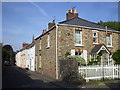
Cardiff Road, Llandaff
Between High Street and Heol Fair.
Image: © Eirian Evans
Taken: 17 Jul 2010
0.07 miles
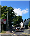
2
From Cardiff Road Llandaff towards the 1st Llandaff Scout Group, Cardiff
The side road leads to the scout hall. 1st Llandaff Scout Group is part of
the Cardiff West District within Cardiff and the Vale of Glamorgan Scout Area.
Image: © Jaggery
Taken: 12 Sep 2017
0.09 miles
3
Barclays Bank, Llandaff, Cardiff
The Cardiff Road bank branch is near the corner of High Street.
Image: © Jaggery
Taken: 12 Sep 2017
0.09 miles
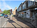
4
Bus shelter outside hospital, Fairwater Road, Llandaff
Image: © David Smith
Taken: 22 Sep 2022
0.10 miles
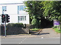
5

Cranmer Court, Llandaff, Cardiff
Flats built c1975 set back from the northwest side of Ely Road.
Image: © Jaggery
Taken: 12 Sep 2017
0.10 miles
6
East side of the Maltsters, Llandaff, Cardiff
The Ely Road side of this http://www.geograph.org.uk/photo/5534403 Cardiff Road pub.
Image: © Jaggery
Taken: 12 Sep 2017
0.10 miles
7
Cardiff Rd, Llandaff
The red traffic light at the far right is at the junction with Fairwater Rd.
Image: © John Lord
Taken: 31 May 2010
0.11 miles
8
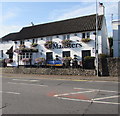
Maltsters, Llandaff, Cardiff
The Cardiff Road side of the pub on the corner of Ely Road, viewed from
the corner of High Street. The Maltsters was formerly the Maltsters Arms.
Image: © Jaggery
Taken: 12 Sep 2017
0.11 miles
9
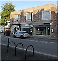
The Pickled Radish, High Street, Llandaff, Cardiff
The Pickled Radish restaurant on the right is at 48 High Street Llandaff. Also in view are the office of Brinsons chartered surveyors and Stewart Greenberg Opticians on the corner of the A4119 Cardiff Road.
Image: © Jaggery
Taken: 12 Sep 2017
0.11 miles