IMAGES TAKEN NEAR TO
Fairwater Grove East, CARDIFF, CF5 2JW
Introduction
This page details the photographs taken nearby to Fairwater Grove East, CF5 2JW by members of the Geograph project.
The Geograph project started in 2005 with the aim of publishing, organising and preserving representative images for every square kilometre of Great Britain, Ireland and the Isle of Man.

There are currently over 7.5m images from over14,400 individuals and you can help contribute to the project by visiting https://www.geograph.org.uk
Image Map
Images are licensed for reuse under creativecommons.org/licenses/by-sa/2.0
Notes
- Clicking on the map will re-center to the selected point.
- The higher the marker number, the further away the image location is from the centre of the postcode.
Image Listing (61 Images Found)
Images are licensed for reuse under creativecommons.org/licenses/by-sa/2.0
Image
Details
Distance
1
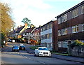
Fairwater Road housing, Cardiff
Flats and houses on the south side of Fairwater Road, viewed from the edge of a railway bridge,
looking towards the Fairwater Grove West junction.
Image: © Jaggery
Taken: 9 Jan 2014
0.08 miles
2
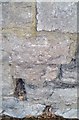
Ordnance Survey Cut Mark
This OS cut mark can be found on the wall of No32 Fairwater Road. It marks a point 32.205m above mean sea level.
Image: © Adrian Dust
Taken: 18 Oct 2018
0.09 miles
3
Steps from Fairwater Road to the railway, Cardiff
Viewed from here. http://www.geograph.org.uk/photo/3848763 There is a locked gate at the Fairwater Road end of the steps,
which may be disused, or perhaps used by railway staff.
Image: © Jaggery
Taken: 9 Jan 2014
0.13 miles
4
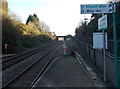
Towards Fairwater Road railway bridge, Cardiff
Viewed from Fairwater railway station. On the right, a path connects the platform with Fairwater Road.
Image: © Jaggery
Taken: 9 Jan 2014
0.14 miles
5
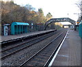
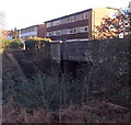
Two bridges viewed from Fairwater railway station, Cardiff
Beyond the station footbridge, a bridge carries Fairwater Road over the City Line.
Image: © Jaggery
Taken: 9 Jan 2014
0.14 miles
6
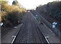
City Line towards Fairwater Road bridge, Cardiff
Viewed from Fairwater station footbridge. http://www.geograph.org.uk/photo/4040640
On the right, a long ramp ascends to Fairwater Road.
Image: © Jaggery
Taken: 9 Jan 2014
0.14 miles
7
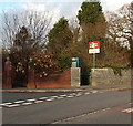
Southern entrance to Fairwater railway station, Cardiff
On the corner of Fairwater Road and Marionville Gardens.
Image: © Jaggery
Taken: 9 Jan 2014
0.14 miles
8
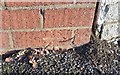
Ordnance Survey Cut Mark
This OS cut mark can be found on the wall NW side of Fairwater Road. It marks a point 25.792m above mean sea level.
Image: © Adrian Dust
Taken: 18 Oct 2018
0.14 miles

10

Ordnance Survey Cut Mark
This OS cut mark can be found on the wall of No24 Insole Grove East. It marks a point 18.306m above mean sea level.
Image: © Adrian Dust
Taken: 23 Sep 2021
0.16 miles